We weren’t able to get the full week of Thanksgiving off work this past year, so instead of our typical weeklong trip, we stayed closer to home, opting for a four-day weekend in Utah. We’ve been to Moab before – multiple times, in fact – but despite those previous visits, there were still three hikes on our to-do list. A four-day trip would give us just enough time for them all!
We left Colorado slightly later than normal on Thanksgiving morning to give the roads time to clear off from the snowstorm that had pummeled the state for the previous two days. By the time we headed out, the roads were mostly dry but the landscape was still dusted with snow and shimmering in the sunlight. It was such a pretty drive!


We arrived in Moab in the early afternoon and headed straight for hike #1: Corona Arch.
This is one of the most popular hikes in the area, and for good reason. It’s not too far out of town, it’s not too long, and there are actually three arches to see along the way.
The Corona Arch Trailhead is located 10 miles (16 km) down Potash Road (UT 279). The parking area is marked and, despite being rather large, was fairly full upon our arrival. I can imagine during busier times of year it would be absolutely overflowing, though there’s some additional parking across the road.

The trail begins with a quick ascent via some rocky switchbacks, before flattening out and crossing a set of train tracks.


From here, we walked along alternating sand and switchbacks, slowly gaining a bit of elevation for the next 0.4 miles (0.6 km) to the junction with the Pinto Arch trail. We didn’t realize it until the hike back, but you can actually see Pinto Arch from here, way off in the distance.
From the junction, we headed left, following signs and painted blazes toward Pinto Arch. The path is mostly slickrock, but as long as you keep an eye out for the blazes, navigation isn’t difficult.

After just over half a mile (0.8 km) and 350 feet (105 m) of elevation gain, we reached the base of the arch. To our surprise, especially given the number of cars in the parking lot, we were the only ones there!


Pinto Arch is a pothole-style arch, meaning it’s oriented horizontally rather than vertically. In fact, unless you’re at the right angle to see the sky through the arch, it just looks like a large alcove.


After retracing our steps back to the main trail, we continued the final 0.5 miles (0.8 km) to Bowtie and Corona Arches. This is where things got fun. Or scary, I suppose, depending on your level of comfort with scrambling, heights, and ladders. We thought it was fun!


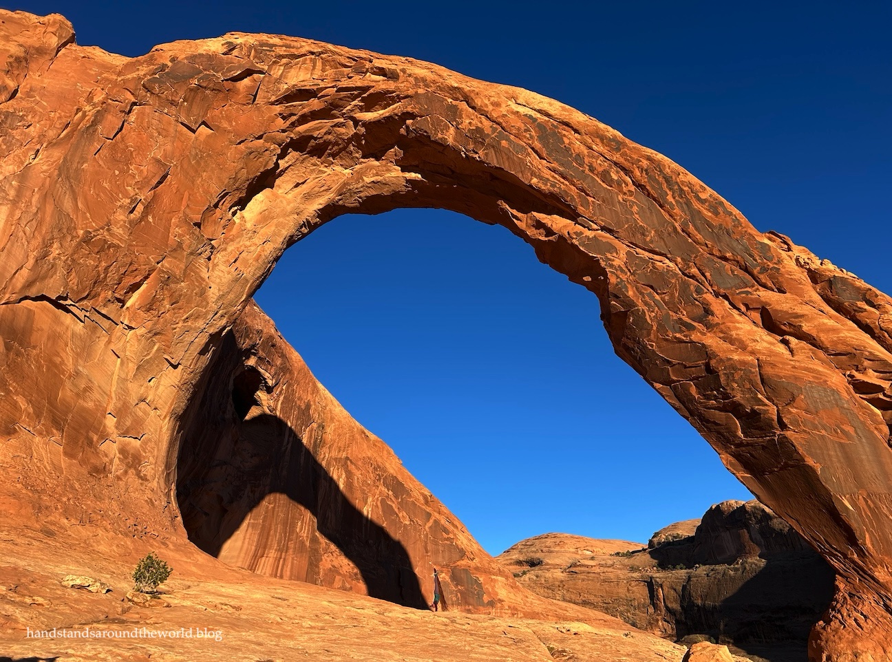
Now higher up the rock walls, we could see both arches ahead of us. All three arches on this trail were uniquely shaped, but we especially liked the way Corona Arch branched off from the rock wall. It almost looks like the leg of an insect or – if you’ve ever watched the show Firefly (and if you haven’t, you should) – a leg of Serenity.

The trail continues around the edge of the terrain, ascending slightly more to the base of Bowtie Arch, named for its resemblance to a bowtie – albeit a lopsided one, with one half forming a pothole-style arch and the other half forming an alcove. There was no one here when we arrived either, the people ahead of us all having moved on, so we took a few minutes to enjoy the solitude and eat a snack beneath the arch.

From here, it’s just a short walk over to Corona Arch.
I’d seen photos of Corona Arch before, so I knew it was large, but I’m not sure I was entirely prepared for just how large it is. You may have to zoom in to see me, but I am in fact in the photo below, doing a handstand underneath the arch.

We were late enough in the day that most people began heading out not long after we arrived, and I was excited to also capture some photos of the arch with no one in them.


After enjoying an unexpected couple minutes of solitude at Corona Arch (I can’t believe we had all three arches to ourselves, at least for a short time!), it was time to start heading back. The sun was dipping low in the sky – as you can probably tell from the shadows in my photos – and the ladder and chain weren’t obstacles we wanted to navigate in the dark.
I will say, it was more difficult to descend that section than it was to ascend. Thank goodness for the chain, because the sandstone is slippery. It’s also easier to go down backwards, as your toes will fit nicely into the divots in the rock.
With the hard part done, from here it was a fairly casual walk back to the car, giving us just enough time to make it back to the main highway before sunset.


Now it was time for Thanksgiving dinner!
Up next: a comprehensive guide to Arches National Park
The Important Stuff:
- Getting there: the Corona Arch Trailhead is located 10 miles (16 km) down Potash Road on the right. It’s well-marked and there is a large parking area and a pit toilet.
- Fees and passes: none.
- Hiking: roundtrip to Corona Arch is 2.2 miles (3.5 km) with 850 feet (260 m) of elevation gain. To add on Pinto Arch (which I recommend), add 1.2 miles (1.9 km) and 485 feet (150 m) of elevation gain roundtrip.
- Where to stay: the trailhead is close enough to Moab that it’s easily accessible from any lodging or campsites in the area. There are also quite a few campgrounds along Potash Road, including right across the road from this trailhead. Be sure to check the campground information in advance, as not all locations have restrooms or potable water.
- Other: while the exposure isn’t extreme, the ladder, chain, and one stretch that’s somewhat close to an edge may make this trail less enjoyable for those with a fear of heights or exposure.
Leave a Reply to M.B. HenryCancel reply