Alternate post title: Finally.
After being forced to cancel this trip at the last minute due to weather on two previous Labor Day weekends, I was approaching this year’s trip with the expectation of having to cancel again.
But, as they say, third time is the charm!
Kings Peak – elevation 13,528 ft (4123 m) – is the highest point in Utah, the seventh highest of the state high points, and one of the more challenging to reach. It’s not technical. But it is long. The shortest route comes in at about 27 miles (43 km) round trip, meaning you need to be a trail runner or an exceptionally fit and ambitious hiker to do this in a day. We are neither, so for us it was a 3-day/2-night backpacking trip.
We set out bright and early on the Friday before Labor Day for our drive to Utah. The trailhead was most of a day’s drive away, a flat and windy journey through southern Wyoming. A drive during which the sky became progressively smokier, forcing me to desperately cling to the weather forecast that promised the smoke wasn’t as bad in the mountains and would be blowing out overnight when the wind changed directions.
The forecast turned out to be correct, and we arrived at the trailhead to sunshine and blue skies.
The main approach to Kings Peak is from Henry’s Fork Trailhead in the Wasatch National Forest. The final hour of the drive was completely out of phone service. At one point, we drove a 27 mile (43 km) road and saw just one car. The Uinta Mountains are very remote, and while we were anticipating seeing a few people on this hike given that it was a holiday weekend, we were not anticipating arriving at the trailhead at 1:00 pm on Friday to find the parking lot already pretty full. By the time we returned on Sunday, cars were overflowing out of the giant overflow lot. This is a more popular hike than I realized!
After a quick lunch, we geared up and set off on the Henry’s Fork Trail, following signs for Dollar Lake. A short distance in, we crossed into the High Uintas Wilderness, where we would remain for the duration of our hike. The first bit of the hike, though, isn’t a good introduction to the beauty of the Uintas, with the wide open meadows and steep reddish mountains largely obscured by pine bark beetle infested trees. The forest here is in truly awful condition.
But finally, just over 3 miles (4.8 km) in, we caught our first glimpse of King’s Peak through the trees.

From here, the views would only get better.


The bridges, however, did not improve.


At approximately mile 5.4 (8.7 km) is the Elkhorn Bridge and junction (right photo above). Here, we had a choice to make: (a) go right on the Henry’s Fork Basin Trail, which is about 2 miles (3.2 km) longer but passes many lakes before reconnecting with the Henry’s Fork Trail, or (b) stay straight on the Henry’s Fork Trail.
(Who else is now confused by Henry’s Fork Trail vs. Henry’s Fork Basin Trail? Someone really should have given them less similar names.)

We went straight, covering the remaining 2 miles (3.2 km) to Dollar Lake relatively quickly. This is the main camping area; however, the lake and most of the campsites are completely surrounded by trees. It’s also very crowded.
We continued past Dollar Lake and split off onto the Henry’s Fork Basin Trail, pitching our tent in a meadow about 100 feet (30 m) from a small creek, in what is absolutely one of our best campsites of all time!

(I should clarify: in any other circumstance we never would have camped out in the open like this. But the weather forecast called for a 0% chance of rain or lightning for the entire duration of our trip and, in fact, there was a 0% chance of clouds for the first 36 hours. Had there been any chance of storms, we would have found a more sheltered place to stay.)
The total distance from the trailhead to our site was 8.6 miles (13.8 km) with about 1700 feet (520 m) of elevation gain.

With the near-perfect forecast, we knew we didn’t need to begin our summit attempt super early on Saturday. Nonetheless, we were up at dawn and on our way around 8:00am for what ended up being an 8 hour day.
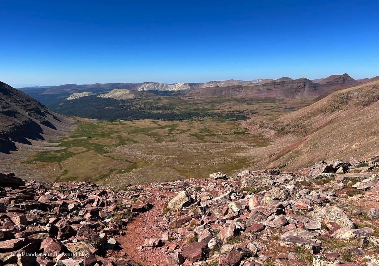
From our campsite, we retraced our steps back to the Henry’s Fork Trail and began the climb to Gunsight Pass. At one point, we turned around to look back across the basin and spotted a bull moose in the distance. Less than 10 minutes later, a female moose dashed across the trail less than 50 feet (15 m) behind us, proving that my days of moose encounters are definitely not over.
(That being said, later in the day we were chatting with a couple who had spent the night at Henry’s Fork Lake and ended up with 8 moose in their campsite, so at least I avoided that.)


From our site to Gunsight Pass was a journey of about 2.2 miles (3.5 km) and 1000 feet (305 m), with most of that elevation gain on the final ascent.
Once we reached Gunsight Pass, we had another choice to make: (a) drop down into Painter Basin on the main trail and then loop around to regain this elevation plus some to reach Anderson Pass, or (b) or take the cutoff trail across the side of Dome Peak to Anderson Pass, a shorter but more challenging route.


Some trip reports I read in preparation for this hike made it sound as though this shortcut was ill-defined and difficult to navigate. I disagree with this. There’s no signage, and it’s not as well-defined as the main trail. It’s certainly steeper and rockier. But to be completely honest, if you aren’t able to route-find and navigate your way through the cutoff trail, you shouldn’t be doing this hike, because the ridge to the summit is this exact same type of terrain.
The cutoff trail is visible in some places and marked with cairns in others, but for the most part the goal is to gain elevation to the first ridge and then roughly traverse the edge of the basin over to Anderson Pass at approximately 12,700 feet (3870 m).


From here, it’s just a giant pile of rocks. Nearly 900 feet (275 m) of them, to be exact, in a little less than 1 mile (1.6 km). There are a few cairns, and a few places with a vaguely defined path, but for the most part you just have to go up. As long as you stay to the left of the ridge, it’s mostly class 1 and 2, with maybe a handful of class 3 sections for those with shorter legs. Some of the rocks are loose, so it was slow-going as we carefully picked our way through this endless talus.


But we persevered and, just over an hour after reaching Anderson Pass, we found ourselves on the highest point in Utah!


Solitude is not to be found on the peak, especially on a holiday weekend. But the summit is large enough to spread out a bit and enjoy the view. And enjoy it we did. We spent 45 minutes gazing out across the landscape, marveling at the similarity of the scenery to the Four Pass Loop and basking in the beautiful weather.

Unlike most mountain ranges in the US, which run north-south, the Uintas run east-west, which apparently predisposes them to particularly strong winds. Lucky for us, those winds were nowhere to be found this weekend. I think this was the weather gods making up for causing our previous two cancellations.
Thank you, weather gods. You are forgiven.
Of course, what goes up must come down, so eventually we retrieved our packs and began our descent of the endless talus. On this kind of terrain, it’s slow going in both directions; it took us about the same amount of time to go from Gunsight Pass to the summit as it did to descend from the summit back to Gunsight Pass.


Beyond that point, though, we were back on a solid trail and it was much faster.
Unexpectedly, we were welcomed back into Henry’s Fork Basin by a couple hundred domestic sheep. Some quick research reveals that sheep grazing is allowed in certain parts of the High Uintas Wilderness. They were scattered throughout the valley for the remainder of the afternoon, but by evening they had meandered off into the distance.


Back at our campsite, we very much enjoyed taking off our packs and boots, relaxing in our camp chairs, and eating some much-earned dinner. We stayed up to watch the sunset and then crawled into our tent, exhausted from our 10 mile (16 km), 2700 foot (820 m) day.


The next morning, it was time to wave goodbye to our beautiful campsite and trek back to the car. The terrain is mostly flat, so it was a relatively smooth and speedy journey.

And then we arrived at the trailhead to find a dog laying underneath our car. Assuming his owner was nearby and he was just chilling in the shade, I greeted him with a “hey, buddy” as we approached. He replied with a growl followed by a lunge in our direction. We backed away and then tried again more slowly, only to be met with more of the same, plus a nice view of his bared teeth. We tried setting off the car alarm, thinking that might scare him away. He didn’t budge.
At a loss, we retreated to the opposite end of the parking lot where another group of hikers was hanging out. Hoping for safety in numbers, all six of us walked over toward the car, my husband and I with our hiking poles and bear spray at the ready. Eventually, two of the hikers were able to use food to carefully lure the dog back under his owner’s vehicle (parked next to ours) and the other two kept a close eye on the dog for us while we shoved our stuff into the car and then climbed in through the passenger side.
Phew.
That was certainly not how we expected this adventure to end.
We thanked the other hikers profusely and then drove down to the overflow parking lot, safely away from the dog, where we could get situated for the drive. And then it was time to head home. It was a very long day. But it was nice to spend the night in our own bed, and it was even nicer to arrive home Sunday evening, well ahead of the hellish Labor Day traffic.
Kings Peak: ✔️
Definitely my favorite of the state high points so far!
Up next: a journey to the summit of Pikes Peak
The Important Stuff:
- Getting there: Henry’s Fork Trailhead is located at the end of Forest Road 077, which requires driving about 15 miles (24 km) of well-maintained dirt roads. In good weather, any car should be able to make it. My maps app got us there without issue. Be sure to screenshot the directions in advance, though, as there’s no phone service for the entire last hour of the drive.
- Fees and passes: none, but be sure to sign the trail register before you begin.
- Hiking: for us, camped about 0.4 miles (0.6 km) down the Henry’s Fork Basin Trail, it was an 8.6 mile (13.8 km) hike in/out (1600 feet/490 m of gain on the way in and 200 feet/60 m on the way out) and 9.9 miles (15.9 km) with 2700 feet (820 m) of elevation gain on summit day. Exact distance and elevation gain varies based on campsite location and the route you take across the cutoff trail and up to the summit. If you don’t take the cutoff trail, add about 4 miles (6.4 km) and 1100 feet (335 m) roundtrip to your summit day
- Where to stay: most people set up camp at Dollar Lake, though there are also sites around Henry’s Fork Lake, and quite a few people (like us) were scattered throughout the meadow between Dollar Lake and Gunsight Pass. For late arrivals, you could hike in 3 miles (4.8 km) to Alligator Lake or camp somewhere near the Elkhorn bridge just past mile 5 (8 km). From Dollar Lake, it’s about 6 miles (9.6 km) one-way to the summit, so camping any further down the trail would make for a very long summit day.
- Gear: see this post for a list of backpacking gear and other information on planning a backpacking trip.
- Other: while bear canisters/ursacks and WAG bags are not currently required here, I recommend both, the former because there is a lack of trees suitable for a proper bear hang and the latter – especially if camping in the meadow – because digging catholes disturbs the subalpine plants.
Leave a Reply to travelling_hanCancel reply