My birthday is in the summer and, in most cases, you could pretty confidently plan an outdoor celebration and assume the weather will cooperate.
In the Rocky Mountains, as it turns out, it’s not such a guarantee. In fact, it snowed on my 8th birthday and my planned outdoor party had to be moved indoors; 8-year-old me was devastated.
Nowadays, I’ve traded birthday parties for birthday hikes, and there have been at least a couple years where these plans were thwarted by fickle mountain weather. This was one of those years. So rather than summiting two 14ers on my actual birthday, my friend and I ended up climbing a 12er a few days later.
Saint Vrain Mountain is located right on the boundary between Rocky Mountain National Park (to the north) and the Indian Peaks Wilderness (to the south). There are two trailheads for this hike: the main Saint Vrain Mountain trailhead at the end of Ski Road (Rd 116.1) just past the town of Allenspark, and a second at the end of Rock Creek Road, which branches off Ski Road and continues for another 3.5 miles (5.6 km). The latter is a shorter hike, but reaching that trailhead requires a high-clearance 4WD vehicle.
We pulled into the Saint Vrain Mountain trailhead – easily reachable in a Subaru and reachable, though with some difficulty, in a sedan – around 7:15am on a Saturday morning and found parking already pretty full. There are spots for about 10 cars in the main lot, with room for another 5-10 along the road just before the trailhead. Aside from this, you’d have to park a ways back down the road.
The first 2.5 miles (4 km) of this hike is in the trees, the trail ascending the drainage of a creek that doesn’t seem to have a name. This section of the hike isn’t all that remarkable. It’s a steady climb, gaining about 750 feet (230 m) per mile with very little reprieve. It’s also a very rocky trail. It was slow going, though that had less to do with the rocks and more to do with the fact that I couldn’t seem to catch my breath.

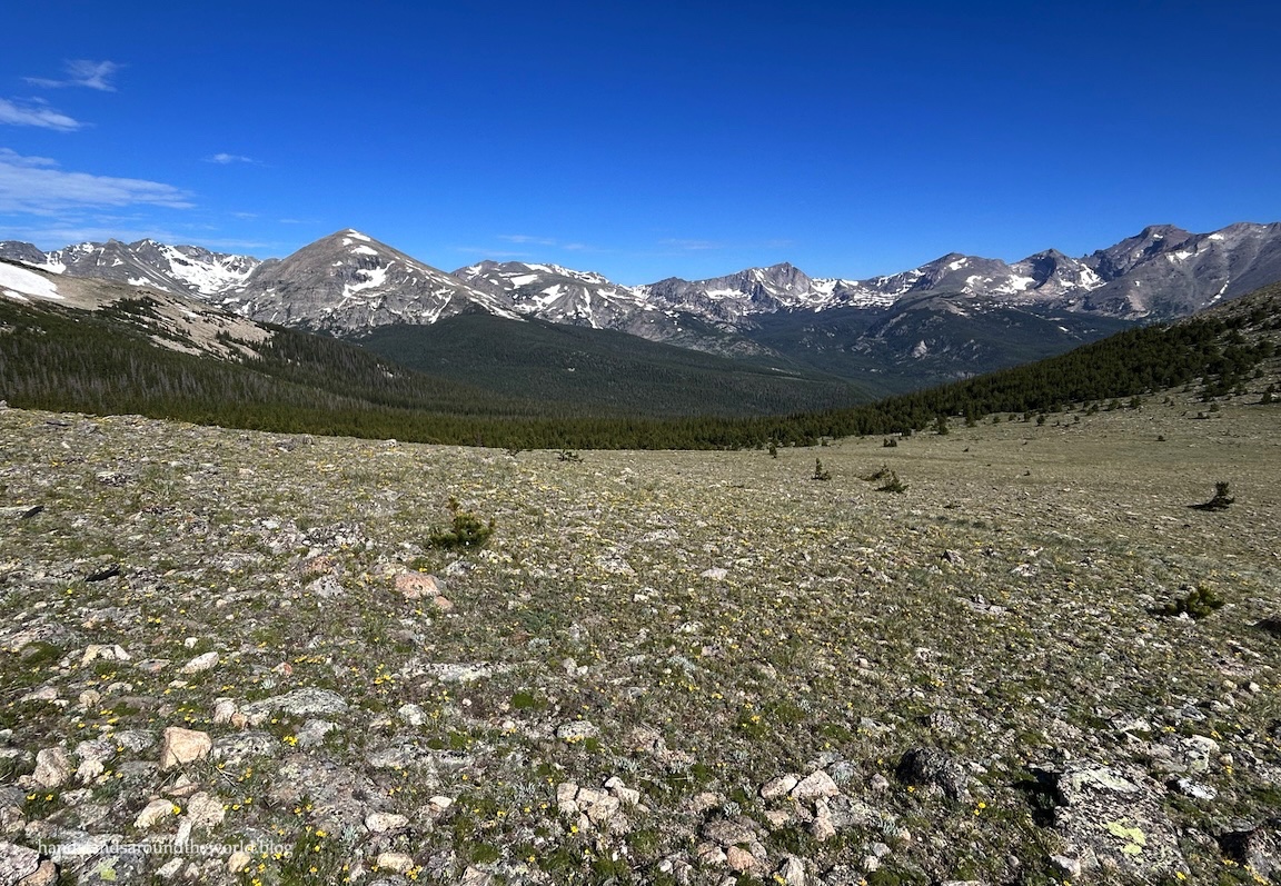
Just shy of the 3-mile (4.8 km) mark, the forest gives way to krummholz and, eventually, alpine tundra. As you know if you’ve followed me for a while, this is my favorite place to be. If I could, I would spend my entire life basking in the beauty of alpine summer.


Despite the fact that the snow was really hanging on in the high country this year (it was late June and many trails remained impassable), alpine summer had, in fact, begun. The sun was shining, the air was cool but not cold, and the ground was covered with wildflowers.


Above treeline now, the trail curves gently to the south and makes its way to the base of Saint Vrain Mountain. Sections were muddy from snowmelt, and we did have to go out and around one sketchy looking snow bridge, but navigation wasn’t difficult.

The trail also crosses briefly into Rocky Mountain National Park here. In compliance with the rules of the national park, dogs are technically not allowed on this trail. However, it’s a bit of a grey area, and there are also no signs explicitly stating this rule. Many people did, in fact, have their dogs with them.

Shortly after exiting the park, there will be a trail on the right that ascends to the summit. There’s no sign and it’s not a well-established trail; we actually missed it at first. The trail roughly parallels the national park-wilderness boundary, which is delineated by metal posts. If you stay close to the posts and rock hop your way up, you’ll make it to the summit.

From the turnoff, it’s 0.6 miles (1 km) and about 800 vertical feet (245 m) to the summit; not an easy climb by any means. It took me… longer than I care to admit. Despite having climbed a 14er five days earlier – a 14er in which the trailhead was at about the same elevation as the summit of this peak – I was really struggling. I felt worse on this hike than I had up at 14,000 feet. It was definitely an off day for me.
But I made it!


The actual summit is fairly large, with a couple high points. The first one is the true summit, but the view is better from the second one, in my opinion. We walked over to this second lower summit and found a spot to sit down, enjoy the views, and have a snack. It was a bit windy and cool, but not nearly as bad as some summits I’ve been on.

To the south we could see the mountains of Brainard Lake Rec Area. To the north was the Wild Basin area of Rocky Mountain National Park, including Sandbeach and Finch and Pear Lakes.


After about 20 minutes on the summit, we began making our way back down to the main trail. It was slow going as we navigated the rocks and a couple lingering patches of snow. My feet were not entirely dry by this point, and my friend’s ankles were protesting quite a bit. And we still had 3.5 miles (5.6 km) of rocky descent back to the car. It felt a little bit like it was never going to end.

And yes, those black spots are bugs.
Not too far from the car, we came upon a grouse near the trail. We didn’t really think anything of it until we spotted her little grouse babies on the other side of the trail. They were super cute and tiny and fluffy.
We were also standing between her and them.
At first, she simply darted across the trail in front of us and then allowed us to keep going. But apparently I wasn’t moving fast enough and… well. The video is below.
And that’s really all there is to say about this one. It was a challenge. It wasn’t my best day on the trail. Despite the struggles, though, it was worth it.
Chasing alpine summer always is.
Up next: a hike to a beautiful alpine lake
The Important Stuff:
- Getting there: The Saint Vrain Mountain trailhead is located at the end of Ski Road (Rd 116.1) in Allenspark, Colorado. A standard maps app got us here without issue. The road is in decent shape and, judging by the cars in the parking lot, navigable by most vehicles in dry conditions.
- Fees and passes: None for day use. This trail enters into Rocky Mountain National Park, but is exempt from the entrance fee. However, because it’s in the park, dogs are technically not allowed.
- Hiking: roundtrip distance is about 9.1 miles (14.6 km) with 3325 feet (1015 m) of elevation gain, though will vary slightly depending on the exact route you take on the final section up to the summit.
- Where to stay: This trail is easily done as a day hike from Denver, Boulder, Fort Collins, etc. However, if you wanted to camp, there are various frontcountry options in the surrounding national forest. There are no RMNP backpacking sites here, but with a Middle St. Vrain backcountry zone backpacking permit you could spend the night along the non-RMNP portion of the trail.
- Other: as with all exposed trails, be sure to start early so you’re back below tree line by noon at the latest. Once you’re above the trees on this one, there is no shelter.
Leave a Reply to rick0427Cancel reply