For at least 10,000 years, the desert southwest has been inhabited by humans. Initially, nomadic groups roamed through the region, but starting in about 500 CE, as farming proliferated and life became more stationary, permanent settlements were constructed.
Over the next 700 years, thousands of dwellings of many types were built throughout the region, generally centered around a water source. These dwellings ranged in size from single family units to villages of hundreds of people and contained not just living spaces but also storage rooms, ceremonial spaces, and other structures whose function remains uncertain.
At its heydey, it’s estimated that as many as 2500 people lived in the area. While the descendants of these Ancestral Puebloans – the modern day Puebloans – still live throughout the region, the last of these ancient villages were abandoned by about 1250 CE.
When photographer William Henry Jackson arrived in 1874, he named the area Hovenweep, a Ute/Paiute word that means ‘deserted valley.’ Closer examination, though, reveals many remnants of these former inhabitants, some of which are now protected within the boundaries of Hovenweep National Monument.
Compared to the majestic cliff dwellings of Mesa Verde, the ruins of Hovenweep may not look like much. Many have not been excavated. Those that have are incomplete and represent just a small fraction of what once stood on these lands. If you’re planning to visit both places on the same trip, I’d recommend going to Hovenweep first.
But despite these differences, we really enjoyed our visit to the monument.
Table of Contents
- Visiting Hovenweep
- Square Tower/Little Ruin Loop
- Cajon
- Horseshoe and Hackberry
- Holly
- Cutthroat Castle
Visiting Hovenweep
Hovenweep was our home base for our 4 day/3 night Memorial Day weekend trip (which I began writing about in the previous post). I reserved our campsite just a month in advance, and at that time the campground was less than half full. However, despite being pretty far out in the middle of the desert, it ended up being booked solid for the weekend.
It’s a nice campground and we had a quiet experience here. There are about 30 sites, all available by reservation only; personally, I think 13 and 15 are the best. We were in 13.


Some sites will accommodate RVs but there are no hookups. The bathrooms are clean, with running water but no showers. The only annoying aspect was the biting gnats, and they were really only bad on our last night. I ended up with a handful of bites, but it was more just the annoyance of bugs constantly swarming us, seemingly undeterred by DEET or a citronella candle. I probably still have a couple of them in my ears.
Anyway.
Hovenweep itself is comprised of one central and five outlying sites spread across about a 30 minute radius in Colorado and Utah. All can be seen in one day but you will need a car with some clearance for most of them. While the route to the central section (home to the visitor center and campground) is well marked, the same cannot be said for the outlying sites.

Along those lines, if you plan to use your phone as your navigation system, map the directions and take screenshots in advance just in case. Phone service is spotty and depends on your carrier. With Verizon, we had a couple bars of 4G at the campground and visitor center but little to none at the outlying sites.
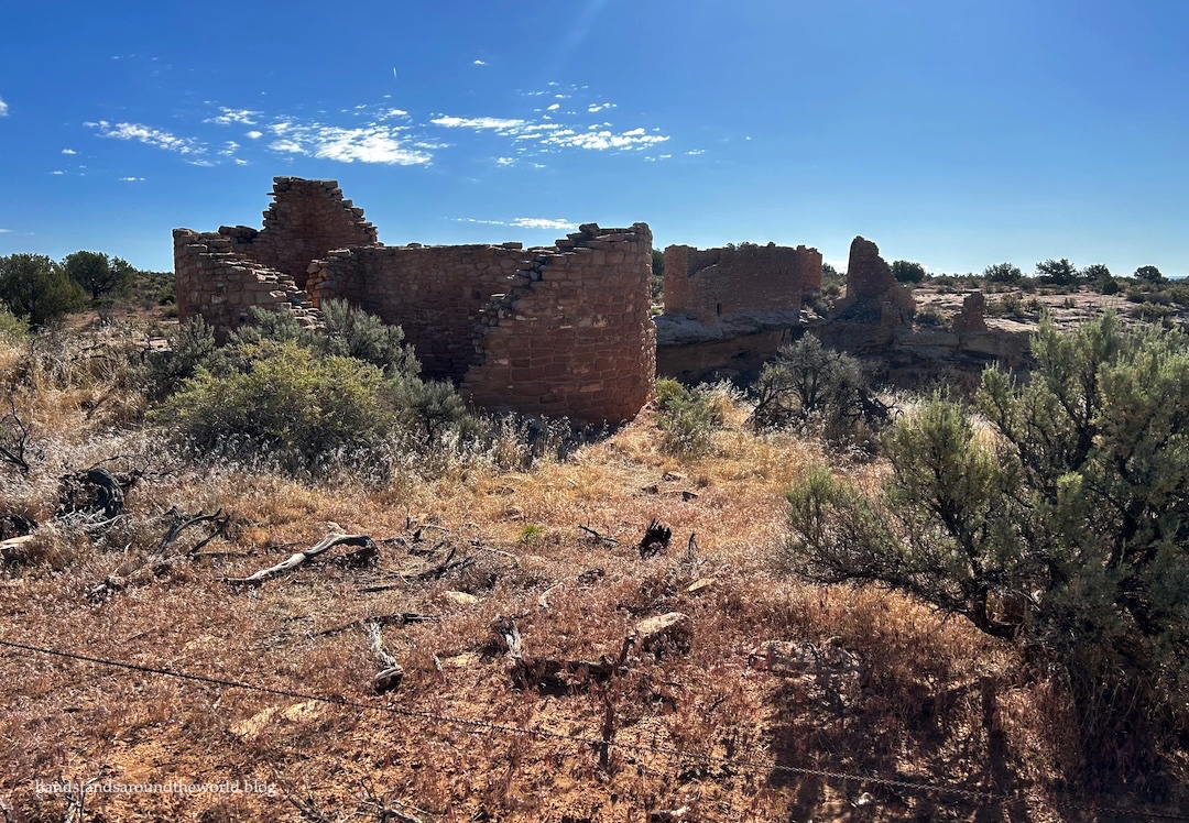
Square Tower/Little Ruin Loop
For best results, begin your trip in Utah at the Hovenweep Visitor Center. The roads here are all paved. Admission is $20/car, or check in at the visitor center with your America the Beautiful pass. An 18 minute film walks you through the history of the region and Hovenweep’s six villages. You can also ask the rangers for updated road conditions.
Behind the visitor center is the Little Ruin Loop. This 2 mile (3.2 km) trail encircles Square Tower Village, which is the most extensive of the six sites. I recommend completing the loop in a clockwise direction to get the elevation gain out of the way first. I also recommend picking up a trail guide at the visitor center before you begin, as it will provide a lot of context to these structures.


One thing that remains uncertain about Hovenweep is the purpose of these towers. They were built during the last few years of occupation of the region, meaning they weren’t used for long. They also aren’t always built on cliff edges or high points, making defense seem an unlikely purpose. While archaeologists will continue to pose hypotheses based on their findings, it’s unlikely we will ever know their true purpose.

Cajon
The southernmost and least visited of the Hovenweep units is Cajon (cuh-HONE). It’s about 15 minutes south of the visitor center on paved and then maintained dirt roads. Any car can make it, though if you don’t have clearance you’ll want to park and walk the short two-track road at the very end. It’s about a 0.3 mile (0.5 km) walk.
From the parking lot, head through the gate and follow the established trail out to Cajon. A few structures remain here, all easily visible from the trail.


Horseshoe and Hackberry
Retrace your steps toward the visitor center and then continue north on Hovenweep Road, crossing back into Colorado toward Horseshoe and Hackberry. These two villages are down the same trail. To reach the trailhead, turn right (south) onto Road 4721. This is an unmaintained dirt road that passes through Canyons of the Ancients National Monument en route to these outlying sites. This road is easily passable with a Subaru. Honestly, you could probably make it most of the way there in a sedan if the road is dry and you straddle the ruts. If you don’t, though, you may end up high-centered.
The trailhead is marked and there’s plenty of parking… not that these outlying sites are busy. We were totally alone at all of them.

Honestly, these two were my least favorite of the Hovenweep sites. There’s not much left, especially at Hackberry. And I was excited to see Horseshoe House since it’s shaped like a double walled horseshoe, but you can really only see it from the back.


Holly
Just 0.8 miles (1.3 km) down the same road is Holly Ruin. We were told not to attempt to reach it without a more capable car, but the road looked fine so we figured we’d go for it and see how far we could get. This was the right decision; we made it to within 0.2 miles (0.3 km) of Holly without issue. I wouldn’t attempt this in a sedan though, as the road does get rougher after Horseshoe.


Holly is a more comprehensive ruin than Horsehoe and Hackberry, and includes a tower, a house that is now tilted thanks to shifting of the rocks beneath, a structure that still contains one of its original 750-year-old wooden support beams, and a small panel of petroglyphs.


Cutthroat Castle
The final outlying site is Cutthroat Castle which, for us, was the Hovenweep highlight. It’s also the hardest to reach – and we unintentionally made it harder on ourselves thanks to a misleading map, a misplaced sign, and unclear instructions. When chatting with a ranger about the road status, she’d informed us we could make it to the first trailhead, about 1 mile (1.6 km) down the road, but shouldn’t drive beyond that.
She wasn’t entirely wrong – but what’s confusing is the fact that there are actually three trailheads, not just the two shown on the Hovenweep map, and her distances weren’t quite accurate.
To reach Cutthroat Castle, follow signs toward Painted Hand Pueblo in Canyons of the Ancients National Monument. This trailhead is about 1 mile (1.6 km) up the road and a sign just past it states “high clearance beyond this point,” so this is where we parked.
It turns out there’s a second trailhead another 0.6 miles (1 km) down the road – this is the upper (aka “first”) Cutthroat trailhead, and where we should have parked, something we only realized in annoyance after we’d walked all the way there. Someone made it there in a minivan, so high clearance is obviously not needed.

In other words, drive 1.6 miles (2.6 km) to the second trailhead, not 1 mile (1.6 km) to the first.
Beyond the upper trailhead, though, you really do need 4WD and high clearance. The road is a mess. There’s a trail from this point, but we decided to just walk the road because it’s shorter.


From the end of the road, follow the short path down to Cutthroat Castle and a handful of other structures. We were able to get up close to the ruins here more so than most other Hovenweep locations, which is the main reason this was our favorite stop.


Obviously, road conditions vary throughout the seasons and may change quickly, particularly after storms. It’s therefore a good idea to begin your visit at the visitor center where you can inquire about the current status. If any of the roads are impassible with your vehicle, it’s always an option to park in one of the many pullouts and simply walk down the roads. It may add a couple miles to each hike, but it can be done. You could also mountain bike the roads to reach the trailheads.
We were fortunate to have pretty perfect weather for the duration of our trip – though I’d have been okay with slightly cooler temperatures – making Hovenweep an enjoyable place to visit. It’s pretty remote, but if you happen to find yourself in southwestern Colorado or Utah, I think it’s worth spending at least a few hours visiting some or all of Hovenweep’s villages and learning about life in the desert 1000 years ago.
Up next: a smattering of southwestern Colorado adventures
Leave a Reply to rkrontheroadCancel reply