There are quite a few versions of the origin story of the name Two Medicine, but most of them refer to two medicine lodge ceremonies – a Blackfeet tradition – taking place in the region at approximately the same time. This southeastern region of Glacier National Park now retains the name, as do three lakes – Lower Two Medicine, Two Medicine, and Upper Two Medicine – and Two Medicine Creek.
When I first planned our trip to Glacier, I didn’t include the Two Medicine area on the itinerary. But by the time summer rolled around, my husband had a few weeks off before starting his new job. Since we were no longer planning around his vacation days, we had the ability to extend our trip, and when we were able to book two nights at Glacier Park Lodge just a couple weeks in advance, it became clear that it was meant to be.


And so our trip began with a visit to Two Medicine. The main activity was hiking to Dawson Pass. However, between this trip and previous ones, I’ve also visited a handful of waterfalls and lakes in the area, so that will be the focus of this post.
Getting there
From either St. Mary or East Glacier, navigate to Montana Highway 49 until you reach the entrance to Two Medicine. It’s well marked. Turn west and follow the paved road along Lower Two Medicine Lake and into the park. Phone service is present but weak so it’s a good idea to screenshot the driving directions in advance. Be sure you’ve also pre-downloaded your timed entry permit.

Running Eagle Falls
Not too far past the entrance station is the parking lot for the Running Eagle Falls Trail, a short, flat, accessible hike. Running Eagle, also known as Pitamakan, was a Blackfeet warrior, and the only woman to ever lead war parties on raids. She was also the only woman ever given a man’s name.
The alternate name – Trick Falls – stems from the fact that water can take two paths. During times of low water, which is unfortunately much of the year, the water of Two Medicine Creek flows almost to the edge and then tumbles down through a hole in the rocks before spilling out the front. During high water, some of the water flows right over the hole and instead falls over the edge.
I don’t know if that description made any sense, but it’s the best I can do. Hopefully the photos below give you a better idea of how it works. I’ve never actually seen it during high water, so my mom donated a photo to the cause.


Hike stats: 0.6 miles (1 km) round trip with 30 feet (10 m) elevation gain
Appistoki Falls and Scenic Point
Continuing up the road, the next big pullout is the parking area for the Scenic Point hike. What’s not advertised on this road sign is that you can also hike to Appistoki Falls from here. While Appistoki Falls is difficult to actually see – so difficult, in fact, that I don’t seem to have a photo of it – the views are what make the hike worthwhile.
If you have the time and energy, you can continue partway up the slopes of Appistoki Peak to Scenic Point. I haven’t done this – though I have hiked above the falls a short distance – but I’m sure the views are even better from the top.

The story of how Appistoki Falls, Creek, and Peak got their names is perhaps my favorite story we were told while in Glacier. Apparently, a white topographer who was traveling through the park with a Blackfeet guide wanted to give a name to what is now Appistoki Peak. Given the size and height of the mountain, he asked the guide about the Blackfeet word for “overseer.” There wasn’t a direct translation, so the guide instead gave him the name of the Blackfeet creator – Apistotoki.
When the topographer wrote it on his map, he missed a syllable and wrote Appistoki, which (hilariously) translates to “baggy earlobes.” So I present to you below, a photo of Baggy Earlobes Peak.

Hike stats: 1.2 miles (2 km) round trip with 260 feet (80 m) elevation gain to reach Appistoki Falls, with the option to continue for an additional 3 miles (4.8 km) and 2100 feet (640 m) one-way to Scenic Point.
Aster Falls
We’ve finally reached the end of the road into Two Medicine, which splits just shy of Two Medicine Lake. Left leads to the boat dock and South Shore Trailhead. Right leads to the campground and North Shore Trailhead. These trails roughly parallel the south and north shores of Two Medicine Lake, respectively, and can be connected to form a loop hike around the lake.
If you don’t feel like hiking quite that far, you can just hike 1.2 miles (2 km) on the South Shore Trail to Aster Falls and continue up to a viewpoint called Aster Park.
I hiked this trail many years ago with my mom. Early on, we spotted a moose standing in a pond in the middle of a large meadow. We continued to climb to two sequential viewpoints of Aster Falls, which is a long series of cascades that drop a total of about 100 feet (30 m).


Beyond the falls, the trail continues its steep climb to Aster Park.
For me, though, this hike will always be remembered as the one where my mom stepped onto a rock in the middle of Aster Creek to take a better picture of Aster Falls… and fell into Aster Creek.
Before you begin to worry – she was okay. She got caught in the current a bit but luckily it was shallow water. She was able to grab onto a rock and I was able to step in and grab her backpack and help her out.
On the list of things not to do in a crisis, I’m pretty sure going into the water after someone is pretty close to the top. Oops.
We were both fine, just soaking wet from the waist down. After a week in a bag of rice, both of our cameras made full recoveries as well.
Moral of the story: when stepping out into the middle of a creek, be sure to put your foot on the dry portion of the rock.

Hike stats: 4 miles (6.4 km) round trip with 670 feet (200 m) elevation gain to Aster Park.
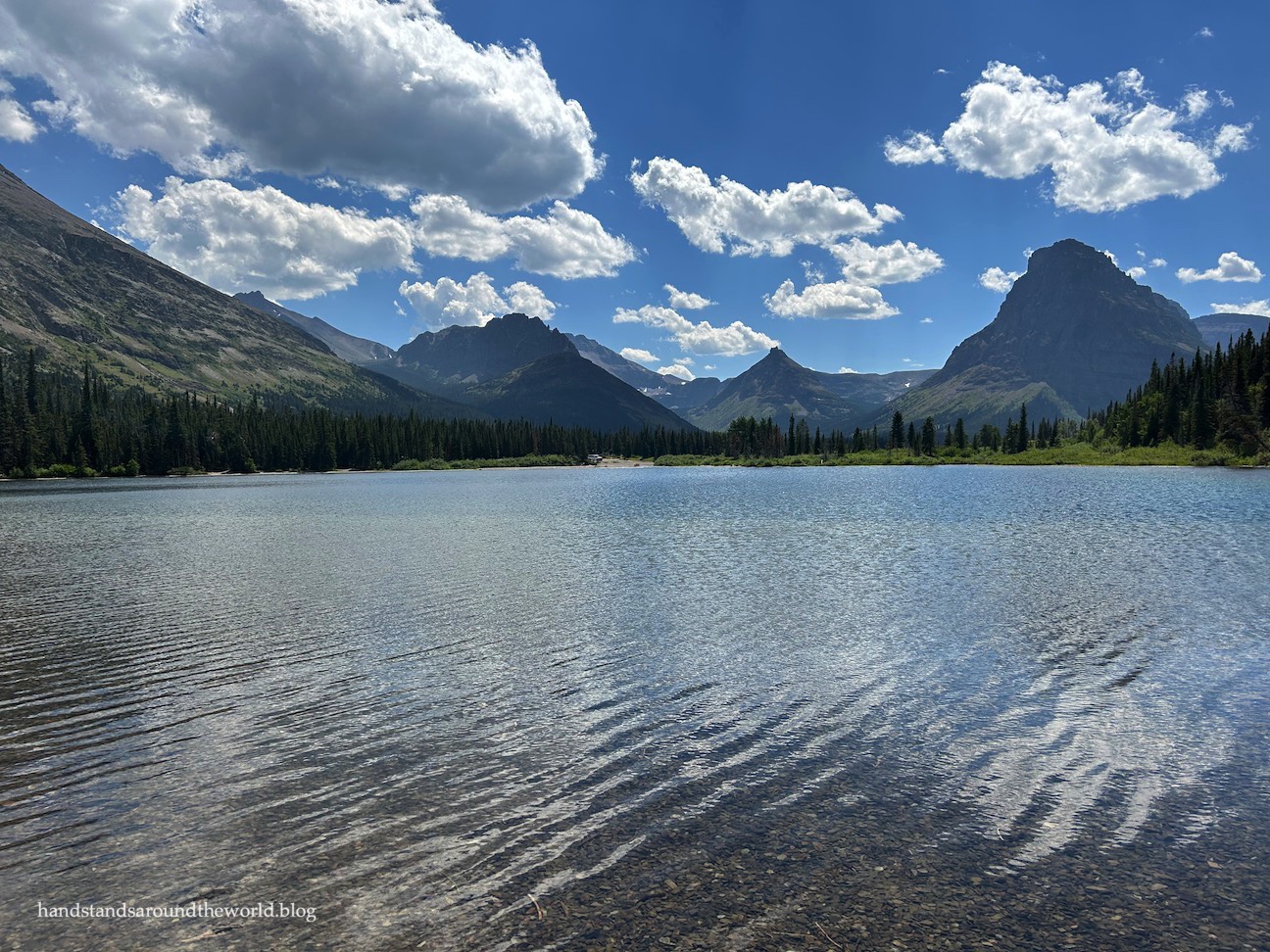
Pray Lake
Back at the end of the road, if you head right instead you’ll find yourself at Two Medicine Campground, North Shore Trailhead parking, and the small but scenic Pray Lake. Even if you’re not camping or planning to hike the North Shore Trail, Pray Lake is worth the stop. It’s clear and shallow, and provides a lovely foreground for the dramatic peaks of the Two Medicine area.

Twin Falls and Upper Two Medicine Lake
And lastly, we have Twin Falls and Upper Two Medicine Lake. There are three ways to reach these destinations: from the North Shore Trail, from the South Shore Trail, or by taking a boat across Two Medicine Lake and hiking a much shorter distance from there. I recommend the boat ride; it’s scenic, it’s narrated, it’s not terribly expensive, and it shortens the time spent on the trail, freeing up time to visit some of these other lakes and waterfalls as well.

However you reach the opposite shore of Two Medicine Lake, you’ll need to follow signs toward the Upper Two Medicine Trail. Just a short ways up is a quick side trip to Twin Falls. If you have the time and aren’t rushing to catch a return boat, it’s worth a brief stop. However, it’s far from the best waterfall in Glacier.


Back on the main trail, continue west along the south side of the jagged Pumpelly Pillar and through a more open area toward the back of the valley and Upper Two Medicine Lake.

Glacier National Park has the clearest water I’ve ever seen, and this is especially evident at Upper Two Medicine Lake.


Hike stats: 4.5 miles (7.3 km) round trip with 430 feet (130 m) elevation gain to Upper Two Medicine Lake from the boat dock. Add approx. 3.5 miles (5.6 km) one-way if you don’t plan to take the boat.
So many people come to Glacier just for a day or two and never make it down to Two Medicine. It’s one of the more underrated sections of the park, but I personally think it’s worth spending an entire day here if time allows. In fact, if you get an early start and are up for hiking about 8-9 miles (13-14.5 km), you could probably see almost everything in this post in one day.
If you have a second day in the area or you’re looking for an all-day hike in Two Medicine, there are options for that, too. Stay tuned!
Up next: a scenic boat ride and a hike to Dawson Pass
Here is a trail map of the Two Medicine area. I also recommend downloading the NPS app and saving Glacier National Park for offline use. You will be able to use the map in the app to track your location.
For more information on visiting Glacier National Park and how to access the Two Medicine area for this hike, please see this post.
Leave a Reply to DianaCancel reply