I know Minnesota has laid claim to the nickname “land of 10,000 lakes,” but it could just as easily be the slogan for northwestern Montana.
Twenty-four hours after arriving home from Minnesota – which, for the record, was way too short a turnaround time – I was on a plane to Montana for our annual mother/daughter roadtrip. The destination this year was the farthest northwest corner of the state, and the theme of our trip turned out to be lakes, lakes, and more lakes.
Not quite 10,000 of them, but many of them, nonetheless.
Day one was mostly just a driving day. We made a few brief stops along the way at some lakes adjacent to the highway before ending our day at North Dickey Lake Campground.


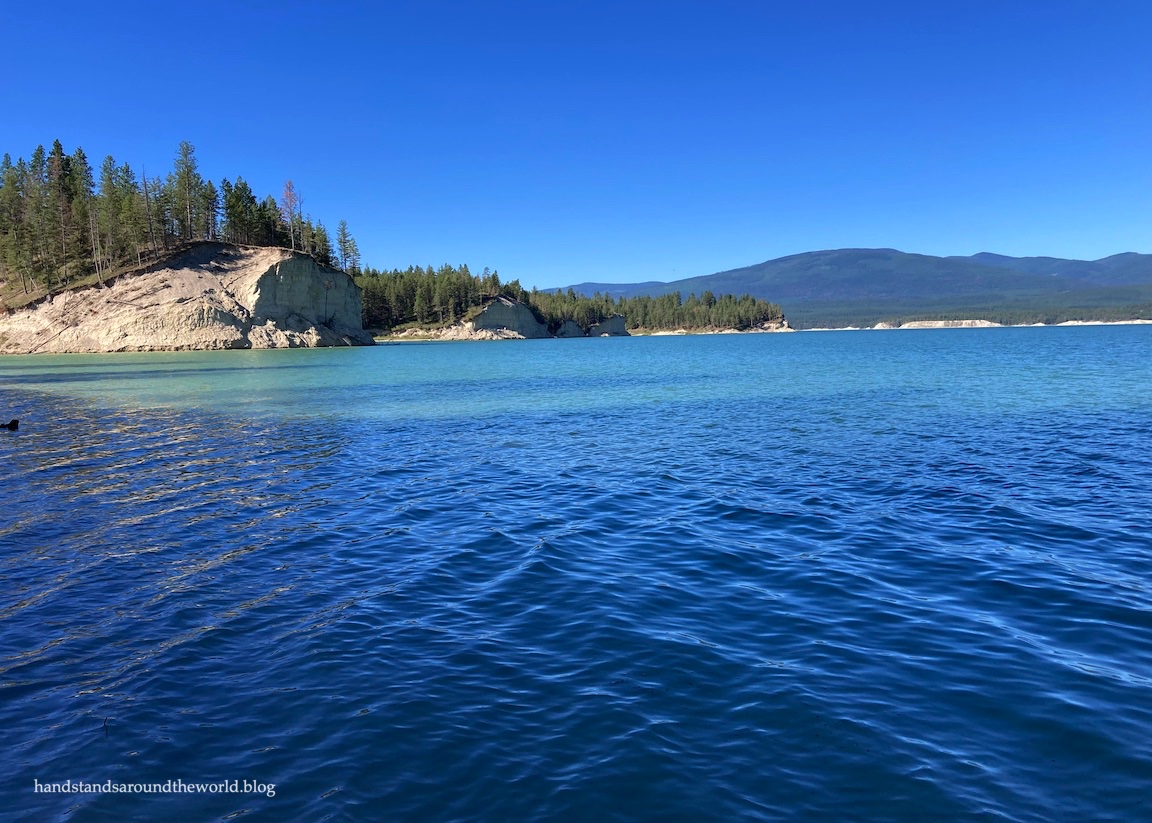
It was July 4th weekend, and by the time we started planning this trip back in February, our camping options were already limited. We couldn’t afford to be picky about which campground we stayed at or which site we reserved, but it turns out that Dickey Lake is a beautiful shade of turquoise and our site, while not right on the lake, was pretty nice as well. We even heard some loons!


The next morning, we continued our northward journey to the town of Eureka, just a few miles from the Canadian border. It’s a small town that was fairly sleepy on a Sunday morning, and the museum building at Riverside Park was closed, but the outdoor portion of the museum was open so we took a few minutes to wander around.


From here, we headed west out of town onto the Lake Koocanusa Scenic Byway, a 67 mile (108 km) stretch of highway connecting Eureka to the town of Libby. The highway runs along the eastern shore of Lake Koocanusa. Most of the shore, at least. The lake is actually 93 miles (145 km) long and extends across the border into Canada. In fact, the name is a portmanteau of Kootenai (the river that was dammed to create the lake) + Canada + USA.

Koocanusa Bridge is the only way across the northern portion of the lake. It is both the tallest (215 feet above the lake) and longest bridge in Montana and, in 1972, earned the title of the world’s most beautiful long span bridge.


Prior to being dammed, the Kootenai River was a main travel route for the Ksanka band of the Kootenai tribe, who were the original inhabitants of this land. In the 1960s the Libby Dam was built, creating the lake and becoming a major source of hydroelectric power for the entire northwestern US. The dam and associated visitor center are operated by the Army Corps of Engineers, with the latter being free and open to the public.


From here, we continued into Libby and beyond. We were no longer on the Lake Koocanusa Scenic Byway; we were now following Highway 2 west along the Kootenai River toward Kootenai Falls and Swinging Bridge. The falls was shorter but much larger and neater than I was expecting, and the swinging bridge definitely lives up to its name. If you don’t like heights, you definitely won’t enjoy walking across it.


Just beyond the falls and bridge is the turnoff for Highway 56. About 20 miles (32 km) down the road is the Ross Creek Cedars, a grove of truly enormous red cedar trees.
This corner of Montana, located on the west side of the Continental Divide and at a lower elevation than the rest of the state, has more of a Pacific Northwest climate that’s ideal for cedar and hemlock trees. I didn’t have my hiking tracker with me, but I’d estimate we walked about a mile (1.6 km) along the trails through this grove of trees, many of which are more than 8 feet (2.5 m) in diameter, 175 feet (53 m) tall, and 500 years old!


There was even one hollowed out tree you could go inside. It was a bit of a tight fit to get in, but once there it was like standing in a cave.
To reach the cedars, turn west off Highway 56 onto Forest Service route 398 and continue for approximately 4 miles (6.5 km). It’s a two-way road, though by width it’s really more of a one-way road, so drive slowly and be ready to pull over in one of the limited pullouts if someone is coming the other way.
Back in Libby, we found ourselves checking into the campsite we’d reserved at an RV park only to be told that they don’t do tent camping. Clearly they need a web portal that prevents such reservations from being made in the first place. Given that we’d already paid for the site and it was just for one night, I really think they could have allowed us to stay. It’s not like our tent wasn’t going to fit in a site with room for an RV.
But they were completely unwilling to budge, and instead they refunded us and directed us down the road to the Fireman’s Memorial Park. It’s a city park that allows camping and we weren’t entirely sure what we were getting ourselves into, but we really didn’t have many other options. It wasn’t the nicest or quietest place ever, but for $10, and just for one night, it did the job.
We ended our day at Cabinet Mountain Brewing, home to some tasty beers, a very delicious margherita pizza with pepperoni and soppressata, and exceptionally friendly staff.

The next morning, on the way out of town, we made one final stop at the Libby Heritage Museum. The building doesn’t open until 10:00am and we didn’t have time to wait, but the outdoor exhibits were open and they were extensive.
It always amazes me how these little towns end up with so much old stuff. In this case, there was quite a lot of mining and logging equipment, hailing from Libby’s origins as a mining and logging town. I expected the mining equipment as Libby has a rather sad history associated with its large asbestos mine (lots and lots of lung cancer, as you can probably imagine), but that actually wasn’t mentioned at all. Instead the focus was on gold mining.


And since I started this post talking about lakes, we’ll end with a few more, seen as we continued south out of Libby on Highway 2.


And lastly, the lovely Leigh Lake, which we hiked to that afternoon, and which I will be talking about in detail in my next post!

Leave a Reply to ChucksterCancel reply