Until this roadtrip, Lake Superior was the one Great Lake I hadn’t seen from the ground.
I’d flown over it before, so I had some comprehension of its immensity.
But as I stood there on the lakeshore for the first time, I might as well have been gazing out over the vastness of the ocean.

Years ago, I planned a roadtrip circumnavigating Lake Superior, but life got in the way and it never came to fruition. Someday, hopefully it will. But for now, we were excited to spend a few days exploring a tiny portion of the largest freshwater lake in the world!
But before we get to the exploration part, here are some fun facts we learned during our visit:
- The original inhabitants of this land are the Ojibwe people, who named the lake Gichigami, which means “great sea.”
- The surface area of the lake is approximately 32,000 square miles (82,000 km2), roughly the size of South Carolina. You may have corrected me in your head after reading the sentence above about Superior being the largest freshwater lake in the world. You’re not wrong, but neither am I; Superior is the third largest when measured by volume (Lake Baikal and Lake Tanganyika are larger), but the largest when measured by surface area.
- Lake Superior contains roughly 3 quadrillion (that’s 3 + 15 zeroes) gallons of water. That’s 10% of the world’s fresh water, and enough to cover all of North and South America to a depth of 1 foot (30 cm).
- At its deepest point, the lake reaches a depth of 1333 feet (406 m). The bottom of the lake here is the lowest point in the continental US, 733 feet (223 m) below sea level. That’s actually lower than Badwater Basin in Death Valley, which is the lowest non-submerged point in the US.
- Once a drop of water enters the lake, it remains there for an average of 191 years.
- It’s the coldest of the Great Lakes, with an average summer water temperature of just 40°F (4°C).
- Lastly, Superior is known for its terrible storms, which have resulted in more than 6000 shipwrecks and the loss of 30,000 lives. The most famous ship to sink in Lake Superior is the Edmund Fitzgerald.
I’ve always heard about the Great Lakes being large enough to create their own weather, but I don’t think I fully understood what that meant until this trip. We spent our days in and out of the fog and rain, with very little sunshine and a lot of wind. Coupled with the wildfire smoke blowing in from Canada, visibility wasn’t the best. But we were determined to make the most of it and ended up having a pretty good time.
Our first two days on Lake Superior were spent at Apostle Islands National Lakeshore. There are twenty-two Apostle Islands surrounding the Bayfield Peninsula in northern Wisconsin. None of them are actually named for the apostles, and all of them already had Ojibwean names before missionaries and traders gave them their English names; Manitou Island is the only one that retains its Ojibwe name on maps today. Twenty-one of these islands are uninhabited and are part of the National Lakeshore.

There are no bridges to any of the islands; boat is the only way to reach them. If we were much more experienced, we could have rented kayaks and spent the day paddling from island to island. But Lake Superior is prone to heavy storms and large waves – some ship captains say it’s harder to navigate than the ocean – and it quickly became clear that we lack the necessary skill and water rescue training to safely set off on our own. So I turned my attention to option two: guided boat tours.
Apostle Islands Cruises is the authorized concessionaire within the park and offers various scenic cruises through the islands, including some that stop at an island for a couple hours, some that will drop you off on an island for the night (camping permits required), and some that simply meander through the islands before depositing you back on the mainland.
I wanted to stop at an island, but I also wanted to see as many islands as possible; no single tour fulfilled both options to my satisfaction, so I ended up booking two: a morning Stockton Island Cruise and a late afternoon Grand Tour.
Stockton Island is one of the closer ones, but it still took about an hour – a rather unpleasant hour, mind you, because the boat was absurdly loud – to reach the Presque Isle dock from the mainland.


Stockton Island – the second largest of the Apostle Islands – is home to a visitor center and hiking trails. We disembarked and then set off on foot for some exploration. One of the rangers was offering a guided hike following the same trails we were planning to take so we decided to join her and ended up being the only ones. I’m not usually one for guided hikes, preferring to go at my own pace, but she walked at a good speed and we enjoyed learning about the flora, fauna, history, and geology of the island.


The steady rain and abundant mosquitoes, however, were less enjoyable. On the calm side of the island, they would swarm you the minute you stopped walking, a problem we solved by just not stopping. On the windy side they were almost non-existent, making the latter our preferred part of the island.


But even if the mosquitoes hadn’t factored in, this would have been my favorite part of Stockton Island thanks to the presence of a pine barren, which was an ecosystem I’d never seen – or heard of – before. Pine barrens are a somewhat desolate place, typically a result of poor quality soil (in this case, it was pretty sandy). As you know if you’ve followed me for a while, I really love desolate landscapes, and would have spent much more time in the pine barren if we hadn’t had a boat to catch.


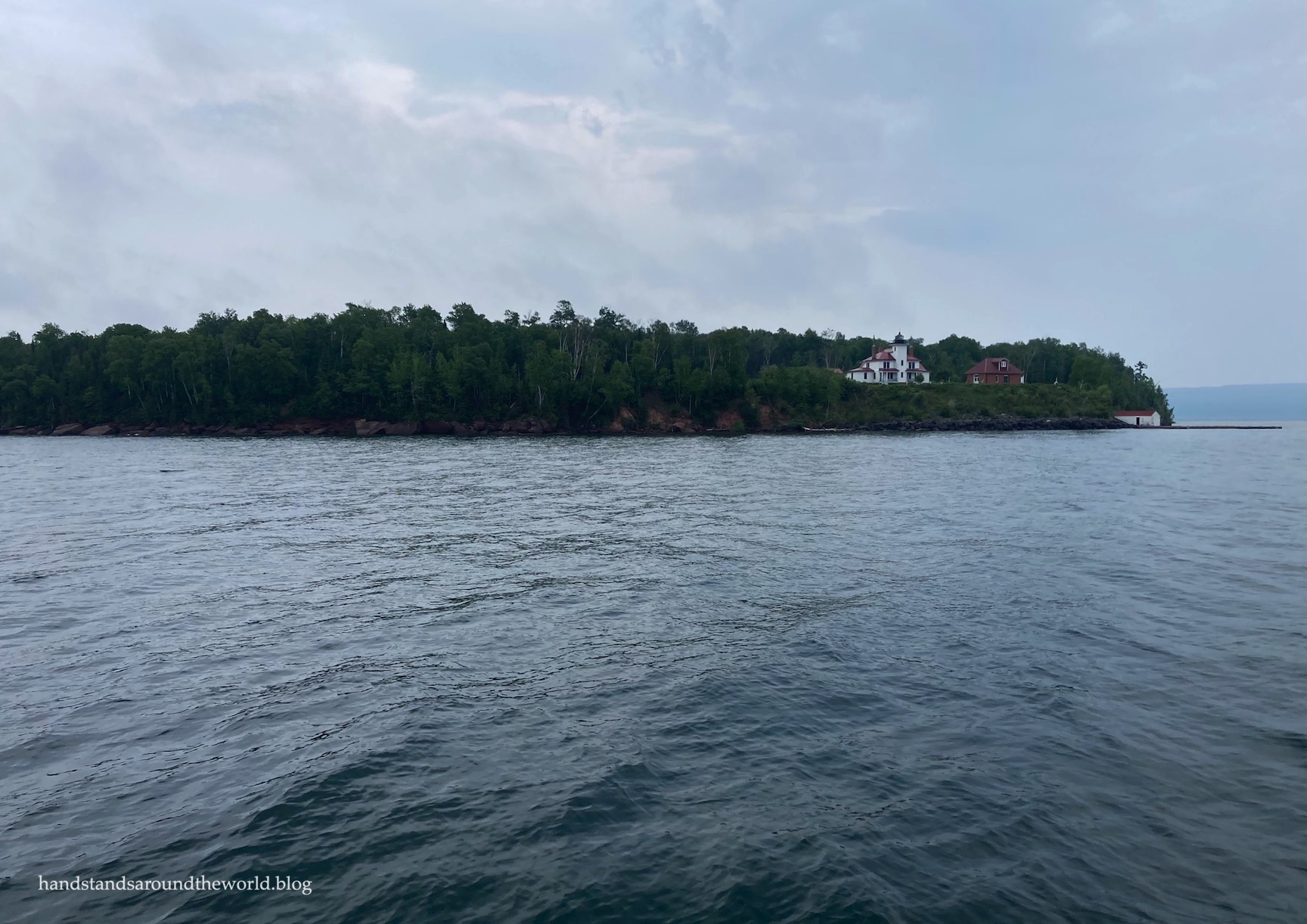
The Grand Cruise is a narrated journey that travels 55 miles (88 km) around most of the Apostle Islands, heading all the way out to Devil’s Island – home to some of Apostle Islands’ famous sea caves – and passing by Raspberry Island on the way back to the mainland.
Apostle Islands is home to more lighthouses than any other NPS unit in the country, with a total of nine spread across six islands. Had it not been so foggy, we might have seen a couple more of them. We also would have seen almost all of the islands, but with the fog constantly rolling in and out, there were a couple we couldn’t see at all and a few that were a mere blur through the clouds.
(Please excuse the reflections in some of the photos; the guy next to me was wearing fluorescent green and it was difficult to avoid capturing the reflection of it in the windows.)


The captain narrated almost the entire journey (complete with lots of dad jokes), save for the part where he was navigating us through some extremely choppy water.
We were already in line at the dock when the boat returned from the previous cruise, watching as water drained out the bottom almost continuously for 20 minutes, which led my husband to question whether the boat had really taken on that much water.
By the time we were approaching Devil’s Island, it was very clear the answer was yes. The waves were threatening to send us out of our seats and sheets of water were crashing up and over the entire vessel.
And this was just a typical June day on Lake Superior.
Normally I love to be outside at the bow of a tour boat, but in this case I was very glad we were sitting inside.

Then a thunderstorm rolled in, so we all hunkered down inside as the captain blazed a fairly quick path back to the mainland.
This marked the end of our time out on Lake Superior itself, so that’s where I’ll leave off for today. However, 12 miles (19 km) of the Bayfield Peninsula shoreline are also included within the National Lakeshore boundaries, and we spent our second day exploring the mainland, including even more sea caves.
Stay tuned!
The Important Stuff:
- Getting there: the Apostle Islands are off the coast of the Bayfield Peninsula in northern Wisconsin. A GPS should get you to the visitor center and boat docks without issue, just be sure you’re headed to the correct tour company.
- Fees and passes: there is no entry fee to Apostle Islands. However, boat tours, boat rentals, and island camping permits all require a fee. Be sure to book tours and permits in advance! More information can be found here.
- Where to stay: according to the website, the only camping options within the National Lakeshore are backpacking sites on the lakeshore or the islands. Boat shuttles and boat rentals are available. However, there were multiple people camped at Little Sand Bay Visitor Center, and the visitor center was open and staffed, so I’m assuming that means camping there is okay. Otherwise, if you want to stay on the mainland, you’ll need to book a private campground or a hotel.
- What to do: the most obvious activity is to get out on the water, either on a tour boat or a sea kayak (beware that you need to be very experienced and have water rescue training in order to attempt this on your own). Take a tour around all the islands or get dropped off on an island to explore on your own!
- Other: I don’t think I could ever emphasize the volatility of the lake enough. Expect it to be cold and choppy, even on relatively nice days, and know that there’s a decent chance your tour will get cancelled due to weather and/or big waves. All the tour companies allow you to reschedule so it’s best to give yourself a few days in the area so you have some flexibility.
Leave a Reply to Lyssy In The CityCancel reply