Day 2 of our New Mexico road trip was somewhat of a failure in planning.
I did plan. I planned a lot. Too much, in fact.
And had it been July, with 14 hours of daylight and the endless motivation that can only be found during summer, we might have pulled it off. But in November, with limited daylight, it quickly became clear we weren’t going to make it through everything I’d added to our itinerary.
So we ditched our plan to pop over to El Morro National Monument while we were in the area, and we skipped a visit to the Bandera Ice Caves (which were closed for the season anyway, marking another failure in planning), and instead focused on seeing as much of El Malpais as we could in the hours we had.
El Malpais – pronounced “mal-pie-ESE” and meaning “bad country” in Spanish – is part National Monument and part National Conservation Area (NCA), located about an hour west of Albuquerque on the edge of the Colorado Plateau. This high desert environment is, upon first glance, desolate. But closer inspection reveals plant and animal life tucked in amongst the rocks, including a handful of endemic species. These landscapes are what we would spend our day exploring.
We began at El Malpais Visitor Center in Grants, NM, which was altogether disappointing. If you’ve arrived in the area and have absolutely no idea what to see or do, this would be a great place to stop. If you already have a plan, it’s largely a waste of time. Other than the passport stamp and a souvenir magnet, I obtained nothing of use here.
On the other hand, if you want to actually learn about the landscapes and history of El Malpais, the NCA Visitor Center is the place. I’d recommend starting here. It’s located on the northeastern edge of the monument off Highway 117.
From here, we continued south on Hwy 117. To our left, red and tan sandstone cliffs towered above the road. To our right, a vast expanse of black volcanic rock coated the landscape. El Malpais is a unique combination of both features. The sandstone was laid down around 200 million years ago, first by wind and later by an ocean. The lava flows then spread through canyons and valleys in the sandstone during a dozen volcanic eruptions over the past 3 million years.
(In more recent history, these lands were home to the ancestors of the present-day Zuni, Acoma, and Laguna Pueblos as well as the Ramah Navajo. Oral histories from these cultures suggest that all were in the area and witnessed the most recent of these eruptions. Later, the land was homesteaded by white settlers, though most eventually left in search of a less harsh way of life.)
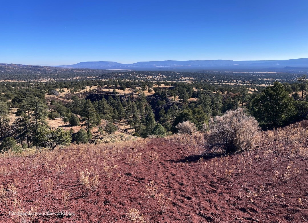
Probably the best view of this rugged landscape is at Sandstone Bluffs Overlook off Highway 117. A 1 mile (1.6 km) gravel road leads out to the overlook. From here, you can climb around on the bluffs and enjoy the view of the lava flows. We also found it to be an excellent picnic spot.


Next up, all the way at the southern end of the monument, was the 1.2 mile (2 km) hike on the Lava Falls Trail across the McCartys lava flow. This is the newest lava flow not just in the monument, but in New Mexico; it took place just 3900 years ago.
I’ve been to Craters of the Moon National Monument, which in my opinion was slightly neater than this, but it was still a fun hike. It was interesting to walk right past the different patterns in the lava and to see the sinkholes and cracks that formed as it cooled. Rock cairns mark the way; aside from those, there was no semblance of a trail. I could see how it would be easy to get lost out here.


Working our way back north, we stopped next at the Narrows Picnic Area. This is in the NCA portion of El Malpais and a trail travels about 4 miles (6.4 km) along the sandstone cliffs. We didn’t hike the whole thing, but a ranger had recommended we walk about the first 0.6 miles (1 km) to the 90° curve in the trail, and I’m glad we heeded his advice because this provided another great view of the landscape.


Our last stop on Hwy 117 was the quick 0.5 mile (0.8 km) round-trip hike to La Ventana Arch, the largest publicly accessible arch in the state (and the second-largest overall).

The final hike (Actually, this was the first one of the day. I’m going a little out of order here. Sometimes these posts just start writing themselves, continuity be damned.) was off Hwy 53 in the northern section of the monument on the El Calderon Trail. This trail can be hiked as a longer loop or a shorter out-and-back. We did the latter, staying right at every junction and following the trail past caves, sinkholes, and a lava trench, through the grasslands and forest, and up to the summit of El Calderon Crater.


There’s a lot more to El Malpais than we saw. It’s an oddly-shaped monument, with one road (Hwy 53) along the northern edge and one road (Hwy 117) along the eastern edge, and that’s about it. If you have a 4WD vehicle, you can drive some very rough roads in the farthest south or west reaches of the monument, but the central portion is designated wilderness and is relatively inaccessible.
All in all, I’d say we saw as much as we could have in one day, but we left a lot unexplored. In addition to the closed ice caves, there are lava caves (also closed in the winter), extensive lava flows, and in the summer there are sunset hikes to watch bats emerge from the caves.
We will definitely be returning to El Malpais in the summer for some ice caves, lava caves, and bat viewing. But for now, we had a nice introduction to this unique and relatively unknown national monument.
The Important Stuff:
- Getting there: the two paved roads into the monument are NM 53 and NM 117; both are off I-40 in Grants, NM via exit 81, 85, or 89. Note that these roads do not connect within the monument; to see everything we did, you’ll need to drive both roads separately which will require some backtracking.
- Fees and passes: none.
- Hiking: There are many hiking trails of varying lengths in the monument and NCA; view the details here. To avoid getting lost when hiking across the lava flows, keep a close eye out for the cairns marking the route.
- Where to stay: There are no developed campgrounds in El Malpais, but backcountry camping is allowed in certain locations within the monument (guidelines). The NCA offers one campground, and there are also a few options in the surrounding BLM and USFS lands. For hotels and other lodging, Grants is the closest town while Albuquerque (about 1 hour away) is the largest.
- Other: This is a relatively remote monument, with little phone service and few amenities. Come prepared with adequate food, water, gas, layers, and a navigational system that will work without cell service.
Leave a Reply