I don’t do well when I don’t have lodging reservations for each night of a trip. It makes me anxious.
But Lake Como Campground in the Bitterroot National Forest doesn’t take reservations, and we really wanted to stay there, so we were forced to go without and hope for the best. To give ourselves the best chance of finding a site, we camped nearby in Hamilton the night before and headed straight to Lake Como first thing on Tuesday morning.


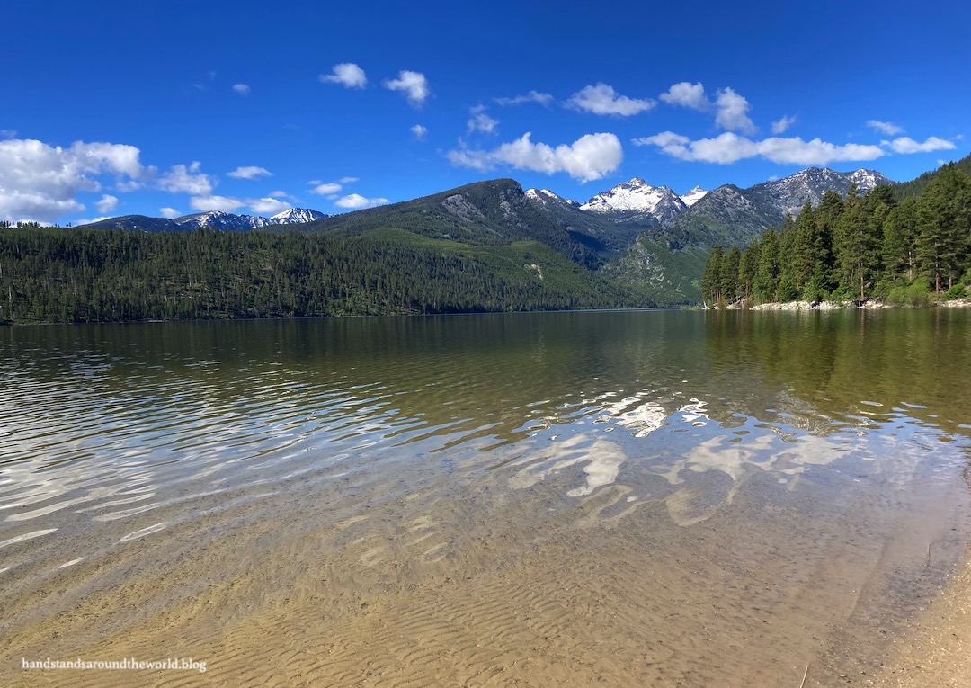
When we arrived at Lake Como, we were pleased to find that four of the twelve sites were available. The campground is set in a forest of towering old-growth ponderosa pines. It’s a beautiful location, as is the lake. It’s easy to see why this area is so popular, and we were excited to have secured a site.


After setting up, we headed out for the day with the goal of hiking to Camas Lakes and driving to Lost Horse Observation Point. Knowing we wouldn’t have cell service, I’d previously mapped the directions and taken screenshots. I was feeling pretty smart and prepared.
These were feelings that would quickly vanish.
From Highway 93, we turned west onto Lost Horse Road. Initially, this is a paved two-lane road that travels past some houses and farm fields and into the mountains. Eventually, the pavement ends but the road remains in good condition. After a couple miles, we reached a fork. Our directions told us to go left. A sign pointed left to Lost Horse Road. So we went left.

The directions then told us to continue for about 7 miles (11.3 km) to Lost Horse Point. We heeded them, referring to the odometer as we made our way up the dirt road in our little sedan. There were some rough sections and some potholes, but it wasn’t too bad. It was slow going, though, and seven miles felt like forever.
The seven miles came and went, and there was no sign or obvious parking area for Lost Horse Observation Point. We figured maybe there was some rounding error and kept going. Mile eight. Still nothing. Nine. Ten. Eleven.
By this point, we were confused and annoyed. But we were gaining elevation and we could see that the scenery was more open up ahead, so we pressed on. Around mile twelve, we hit a locked gate; due to a damaged bridge, the road was closed to vehicles from this point on. We would have to get out and walk if we wanted to go further.
In retrospect, this is when we probably should have realized we were not on the right road and turned around. But we’d come so far, and both the sign and the navigation had pointed us in this direction, so we stubbornly set off up the road on foot in search of the elusive high point. We walked for almost 3 miles (4.8 km), during which time we found a deer, a couple waterfalls, and lots of wildflowers. But no Lost Horse Point.


Upon return to the car, we bumped and bounced our way back down the dirt road, stopping at the National Forest informational sign to closely examine the map… which is when we realized we should have taken the right fork… contrary to what both the directions and the sign indicated.
In summary:
1: Don’t follow the Apple Maps directions.
2: When you reach a fork in the road and the sign points left to Lost Horse Road… don’t follow it. Counterintuitively, Lost Horse Observation Point is not on Lost Horse Road. Instead, go right, following the sign toward Coyote Coulee Trailhead.
3: Once you’re on the correct road and you see a sign listing the distance to Lost Horse Point, reset your odometer and use it to guide you. There will be no sign or any other indication that you’ve reached the correct location, so precision is key.
We were fortunate that there was a car at the random, tiny, unmarked pullout that serves as the parking area, and that two people were at the car, removing their backpacks as though they had just finished a hike. This was our only clue that we might finally be in the right place.
A little searching revealed a path up the hillside. So up we went, hoping for the best. It was a short but steep climb to the top of the hill. Once there, we enjoyed a late lunch with a pretty great view of the surrounding mountains.
But to be completely honest, I’m still not 100% sure this was actually Lost Horse Observation Point.


It was too late in the day now to hike to Camas Lakes, so I guess we’re filing that one away for next time. We’d spent the previous afternoon in nearby Hamilton, Montana, where the brewery we I wanted to visit was closed for a special event, so we’re filing that one away for next time as well.
One thing we were able to visit during our time in Hamilton was the Daly Mansion. Marcus Daly was one of Montana’s three Copper Kings… businessmen who invested in and made millions from the copper mining industry. Most of the mining took place around Butte and Anaconda, but Marcus Daly essentially founded the town of Hamilton to house the people who worked to provide lumber to support mining operations.
He and his wife initially lived in a much smaller house on the edge of town. It was renovated and expanded twice during his lifetime, and after Marcus Daly’s death, his wife Margaret had it expanded on final time to the 25 bedroom, 15 bathroom mansion that still stands today. It’s enormous. And beautiful. Tours are $15/person. We chose the self-guided option, which allowed us to spend as much time as we wanted in each room while also learning about the house from the provided pamphlet.


All in all, this was a lovely (albeit confusing) introduction to the Bitterroot Valley and Mountains!
The Important Stuff:
- Lake Como: from Hamilton, drive 12 miles (19 km) south and turn west onto Lake Como Road. Drive about 4 miles (6.4 km) to the end of the road to reach the lake, beach, and campgrounds ($25/night, no reservations). The road is paved all the way to the lake and passable by any car.
- Lost Horse Observation Point: from Hamilton, drive 9 miles (14.5 km) south and turn west onto Lost Horse Road. At the fork, turn right onto FS Road 496 toward Coyote Coulee Trailhead. Stay right and follow signs to Camas Lake Trailhead and Lost Horse Point. When you see the sign listing the distance to Lost Horse Point, reset your odometer and use it to guide you to the small parking area.
- Daly Mansion: open daily June 6-Oct 1 from 10am-4pm (website); $15/person for guided or self-guided tours
Leave a Reply to alisendopfCancel reply