Normally I’m excited for snowy mountains and frozen alpine lakes and snowshoeing, but this past winter I had trouble locating my enthusiasm.
It might have been because winter took its sweet time arriving in Colorado. The mountains ended the year with snowpack that was far below normal, and it didn’t actually snow on the plains until mid-December (which was a record for latest first snowfall ever).
The rest of winter has been much more wintery and, as I sit here at the end of February writing this, there is snow on the ground and we’re coming off of our coldest week of the year. Once it felt like winter in town, I found myself more excited about winter in the mountains.
And finally, at the end of January, I strapped on my snowshoes for the first time this season.
My friend had stumbled across a rather unknown trail in Rocky that she wanted to check out. Our hike began at the East Portal Trailhead, which is located about 5 miles (8 km) southwest of Estes Park. (This is not to be confused with East Portal Trailhead near Rollinsville, Colorado.) We pulled into the parking lot and found it plowed but empty. It looked like we’d be all alone for at least part of our day.
The trail was snow-covered from the very first step so we put our snowshoes on right away. The hike begins on either the Wind River or the Glacier Creek Trail, depending which direction you want to hike the loop. We began on the Glacier Creek Trail and went right at the first fork, opting to hike the loop counterclockwise. Hiking in this direction would put most of the elevation gain at the beginning of the hike. So up we went.
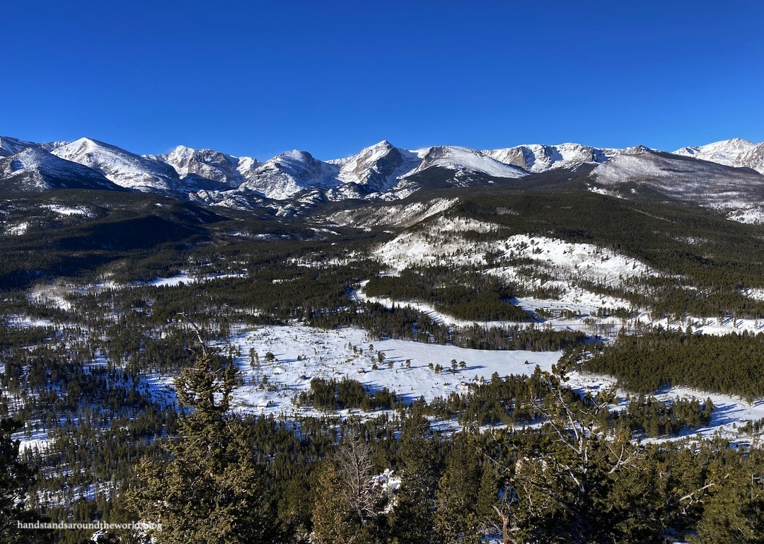
Just ahead was a 9200 foot (2805 m) point called Emerald Mountain. An unmaintained trail branches off and climbs very steeply to the summit. It was challenging to follow the path through intermittent snow and bushes, and eventually there was too little snow and too many rocks to use snowshoes, so we took them off and stashed them by a tree. Shortly thereafter, we found ourselves above the rocks and sinking into knee-deep snow, wishing we hadn’t left our snowshoes down below.


But we made it and were rewarded with some of the best views of the day!


After enjoying the panoramic sights, we slipped and slid our way back down the snow and rocks, recovered our snowshoes, and found our way back to the main trail. From here, it was a fairly gradual walk through the woods. Although this is a lesser traveled trail, there were visible tracks and red markers on trees indicated the route. Most trails in Colorado are not marked in this way, but having the markers made navigation much simpler.


Soon, the trail emerged from the trees into Glacier Basin Campground. I’ve stayed here in the summer and it’s my favorite campground in the park. It’s closed in winter, but boy was it beautiful all covered in snow! The fire grates were buried and the picnic tables were practically at ground level; this was the first time all day we’d been able to really tell how much snow was on the ground.

The Glacier Creek Trail then continues past the campground for another couple miles. But first, we detoured off the loop onto the 0.6 mile (1 km) Glacier Basin-Sprague Lake Trail to Sprague Lake. This is a beautiful and very accessible lake – there’s a parking lot on the opposite side and the trail around it is wheelchair accessible.
Meanwhile, we’d hiked about 2.5 miles (4 km) so far… this is the very long way to reach Sprague Lake. I enjoyed the detour, though, as this view never gets old.

It was calm and sunny so we took a break here before retracing our steps back to our loop. The Glacier Creek Trail continues through the forest, eventually intersecting with the Glacier Creek to Storm Pass Trail. Shortly thereafter, we turned onto the Wind River Trail which paralleled the Wind River all the way back to the trailhead. We couldn’t really see the river due to the snow. We also hadn’t seen many people all day, and part of this section of trail was unbroken so we had to set the tracks… which is always hard work.


All in all, this was a good first snowshoe of the season. Aside from our short but steep detour up Emerald Mountain, the elevation gain was gradual, the forest was peaceful, and the views were nice. It would also be a good trail to cross country ski. And with so many trail junctions, you have the option to make the hike as long or short as you’d like. For us, it ended up being 7.6 miles (12.2 km). Here is a map of our route.

The most exciting part of the day for me, though, was spotting a mountain lion meandering near the highway as we drove to the trailhead! It was the first mountain lion I’ve ever seen in the wild.
Unfortunately, since we were driving I couldn’t capture a photo.
And I guess that’s about it. A lovely snowshoe loop in Rocky and a very unexpected feline sighting.
The Important Stuff:
- Getting there: East Portal Trailhead is located at the end of Tunnel Road (Highway 66) 5 miles (8 km) southwest of Estes Park (be sure your GPS doesn’t sent you to the other East Portal Trailhead in Colorado).
- Fees and passes: there is a $30/car daily or $35/car weekly entrance fee to RMNP; America the Beautiful passes are accepted. From May-Oct, if you arrive between 9:00am-2:00pm you will also need a timed entry permit to access this trailhead. Since you do not pass through an entrance station, both items should be displayed on your dashboard.
- Hiking: there are numerous options for this trail, including the full loop with add-ons as we did, which was 7.6 miles (12.2 km) with 1600 feet (490 m) of elevation gain.
- Other: because this is a lesser-traveled trail navigation may be more challenging, especially in the winter when everything is covered in snow. Be sure to download a trail map in advance so you know which way to go at each junction.
For more information, see my posts on visiting Rocky Mountain National Park and winter hiking tips and safety.
Leave a Reply to salsaworldtravelerCancel reply