Like so many other things since we’ve moved to Colorado, this was somewhat of a third time is the charm situation for us. The first time we drove Independence Pass we were en route to the Maroon Bells, but we’d left home after work and by the time we made it this far it was dark and we couldn’t see much of anything.
The second time over the pass – a few days later, on the way home from that same trip – forest fire smoke was so thick that we also couldn’t see anything. (Literally. At one point, there’s a large lake just a few hundred feet from the road and we couldn’t even see it.)
This past fall, we finally got to drive the pass and actually enjoy the scenery… complete with vibrant fall colors. It’s easy to see why this is a bucket list drive.
Independence Pass is the 36 mile (58 km) stretch of CO Highway 82 between Twin Lakes and Aspen. The road tops out on the Continental Divide at 12,095 feet (3687 m), making it one of the highest paved roads in the US and the highest paved crossing of the Continental Divide in North America (another reason for its bucket list status).
Driving it is an adventure of its own; the road is steep, winding, and, in some places, not quite wide enough for two lanes… despite the fact that it’s a two-lane road. It can be a little nerve-wracking.

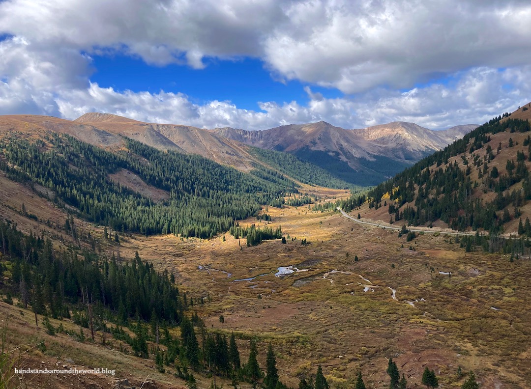
We began our weekend on the Twin Lakes side of the pass – which, by the way, Twin Lakes is worth a visit of its own; you can read all about our winter weekend in Twin Lakes here. As it turns out, it’s a lovely place in the fall too. The bright yellow aspen groves glowed in the sunlight as we drove through.


After a fairly gradual first few miles, a hairpin turn marks the beginning of the steep ascent to the pass. It’s a much more rapid climb from this side, with multiple sharp curves en route to the summit. Because of this and the narrowness of the road, no vehicles over 35 feet long (RVs, trailers, etc.) are allowed on this stretch of road.


After navigating the turns, we arrived at the summit of Independence Pass. It was sunny but also breezy and chilly; autumn had definitely set in at this elevation, and winter was nearing. There is a large parking area at the summit, as well as bathrooms, trash cans, informational signs, a couple small ponds, and a short walk out to the viewpoint. On this particular day, there was also a guy who had somehow ridden his unicycle up the pass. A truly impressive accomplishment.


Once descending from the summit, it was time to do some hiking. As you begin the descent heading west, the Lost Man Trailhead is located at the first hairpin turn. From here, you can hike to three beautiful alpine lakes for a roundtrip total of 8.5 miles (13.7 km). I’m going to write all about this hike in its own post next week, but for now here are a couple of my favorite photos.


There’s a small pullout just past the trailhead with a short path leading out to a memorial bench and a view.

Continuing down the west side of the pass, our next stop was Independence Ghost Town, located in the Roaring Fork Valley at an elevation of 10,900 feet (3320 m). The Roaring Fork Valley – and, in fact, much of the Colorado mountains – is the original homeland of the Ute people. Upon discovery of gold in the 1850s, white settlers began staking mining claims in the valley and forcing the Utes off of their land and onto reservations in the eastern part of the newly-established Colorado Territory.
The town of Independence sprung up during this gold rush; the story is that gold was discovered on July 4, 1879 (in other words, Independence Day), hence the town’s name. The town quickly grew to over 300 people and at least 90 buildings. It also served as a stopping point for people traveling over the pass to Aspen. However, the ore was rapidly exhausted and a brutal winter storm in 1899 chased the remaining residents out of town for good (they apparently escaped to Aspen on skis made of wooden planks).
Some of what remains of the town is visible from the road and more can be seen with a short walk. It’s one of the more intact ghost towns I’ve ever visited.


Our next stop was to hike a short trail to Lost Man Reservoir. Not to be confused with Lost Man Lake. They’re two different bodies of water.


We stopped next at the Braille/Discovery Trail area, home to a picnic area and two trails designed to make the outdoors accessible to all. The Discovery Trail is wheelchair accessible. It leads along the Roaring Fork River and through the forest, with signs along the way explaining the history of the area and some of the native flora and fauna.
The Braille Trail is also a short trail along the river. A rope runs along the side of it to guide the way, and all signs are in Braille. We also viewed an exhibit on the history of Braille, which was really interesting and definitely not something I expected to learn on this trip. It’s a shame there aren’t more areas like this where nature is made accessible to all.

Our final exploration of the day was at The Grottos, a popular waterfall area on the Roaring Fork River. To be completely honest, I thought it was going to be one of those places that’s completely overhyped… but it was actually really neat! The Grottos formed when a glacier eroded away the rock beneath, leaving behind small gouges and forming deep, curved, smooth canyons.


Along the short trail, we passed by glacially-smoothed rock slabs topped with erratics – boulders that were frozen into the glacier, transported in the ice, and left behind when the ice melted.


The third attraction here is The Cascades, a series of small waterfalls on the Roaring Fork River. The erosive forces are very evident here as well on the smooth surfaces and circular shapes of the rocks. This is the oldest rock in Colorado, dating to 1.7 billion years ago!


The final short hike on the west side of the pass is to Weller Lake. We actually stopped here the next morning on our way home, but for the sake of going in order along the highway I’m going to include the photos now. This is a 0.8 mile (1.3 km) roundtrip hike through the forest up to a small lake. The shore is surrounded by boulders and logs. It was a nice quick early morning hike and we only saw a handful of people.

We ended our day just a few miles shy of Aspen at Difficult Campground. The campground is set along the Roaring Fork River amidst the aspen trees. We enjoyed our stay and our site, although in the future I think I would try to find a site closer to the river. As compared to other Forest Service campgrounds, Difficult is on the pricey side. I personally think it’s worth the cost; it’s such a pretty location. It’s also very popular. Securing a reservation can be – well – difficult.

And that wraps up our tour of Independence Pass. I’m glad we were finally able to enjoy the beauty of this area of Colorado, and I’d say the pass lives up to its bucket list designation!
Read more of my Colorado Bucket List series here.
The Important Stuff:
- Getting there: Independence Pass is the stretch of Highway 82 between Twin Lakes and Aspen; it can be reached from either town, but beware that any vehicle over 35 feet isn’t allowed and the road is closed from Oct-May.
- Fees and passes: there is no fee to drive the road or make any of the stops we did.
- Where to stay: for lodging, there are cabins, lodges, and hotels in both Twin Lakes and Aspen. For camping, Difficult Campground near Aspen takes reservations; other campgrounds are first come first serve, as are the handful of dispersed camping spots.
- Other: the summit of the pass is over 12,000 feet (3655 m); be prepared for wind, intense sunlight, and summer thunderstorms. There are no amenities between Twin Lakes and Aspen, so gas up before you begin the drive and have an adequate supply of food, water, and warm clothes.
Leave a Reply