I’ve been hiking since I was too young to remember, and in that time I’ve accumulated quite a few hiking accomplishments. But one thing I’d never done in all 30+ years of my life was go hiking alone.
In general, I don’t consider myself an anxious person. Sure, I have my moments of anxiety when something stressful happens. But for the most part I’m pretty calm and rational… that is, until you put me alone in the wilderness.
I don’t know exactly why this is, but if I had to guess I’d say it’s because I hear news stories at least once a year of someone getting mauled to death by a grizzly bear. Nine times out of ten, that person was hiking alone. And so from a young age, it’s a lesson that was reiterated over and over again.
It’s a lesson that has stuck with me, even though there are no grizzly bears in Colorado. As long as I’m with at least one other person, out in nature is my favorite place to be. Alone, any semblance of my typical calmness and rationality vanishes and all my brain can think about is the list of animals that might jump out of the trees and eat me.
Anyway.
It was early July and my hiking plans for the following day fell through. I still really wanted to get outside, and I was craving some time above tree line, so I decided to finally push through the fear and attempt a solo hike. And sure, maybe a hike in which you’re sharing the trail with roughly 300 other people doesn’t count as “solo” … but I’m counting it anyway.
Mount Bierstadt is one of Colorado’s 14,000+ foot (4267 m) peaks, and the second one that I’ve ever climbed. Bierstadt is exceptionally popular due to its proximity to the major population centers and its status as one of the easier 14ers. Of course, “easier” is a relative term. No trail that starts at 11,500 feet (3505 m) and ends at 14,060 feet (4285 m) is going to be easy. But compared to many of the other 14ers, this one is on the easier end of the spectrum.
The trail is also entirely above tree line, meaning I would always be able to see where I was going… and I wouldn’t be surrounded by trees from which animals could jump out at me. The visibility combined with the fact that there would be plenty of people on the trail made it a hike that I was comfortable doing solo.
So I dragged myself out of bed at 4:00am, and by the time I arrived and hit the trail, the lot was full. Upwards of 500 people hike this trail every day in the summer (not an exaggeration), making the parking situation a nightmare. Waking up at 4:00am is never fun. But every time I get back to the parking lot and see it overflowing with cars, I remember why it’s worth it to get such an early start.

So off I went on my solo excursion.


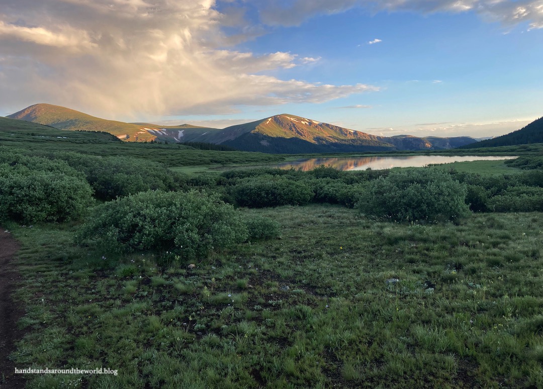
The first mile (1.6 km) or so of the trail weaves through the willows, past Deadman’s Lake, and over a marsh on some boardwalks. It was a chilly morning up in the mountains; the leaves were coated in dew and there was a thin layer of frost on the boardwalk which made it pretty slippery.


Next up was the creek crossing… not an easy task on this particular morning. The good news is that we’ve received so much rain this summer that we are officially no longer in a drought! Everything has been so lush and green and lovely. The downside is that rapidly-flowing streams make for precarious crossings. I was thankful to have packed my hiking poles.


After a relatively flat first mile, a vast majority of the 2850 feet (870 m) of elevation gain now lay ahead of me, spread fairly evenly over the remaining 2.5 miles (4 km) of the hike. It was slow going as always at such a high elevation. I was a little worried; I hadn’t been up above 13,000 feet (3960 m) since the previous summer. But I tried to pace myself and the scenery was so lovely that my frequent photo-taking stops could double as a chance to catch my breath. Before I knew it, I was approaching the summit.


Aside from the lack of oxygen, the hardest part about this final push to the summit was route-finding through a pile of boulders with the sun shining directly in my eyes. There are periodic cairns; I was mostly able to follow them but occasionally got a little off the route. Really, though, as long as you keep moving in an upwards direction you’ll reach the summit eventually.


For me, standing on a mountain peak with a 360° view is something that just never gets any less incredible. I love being able to see so far in every direction. I love the feeling of being higher than the surrounding landscape. I love the fresh air and the sunshine and the rugged ridgelines. If I could spend my entire summer above tree line, I absolutely would.


I spent about 25 minutes on the summit, eating a snack and soaking in the views. Thanks to my early arrival and the fact that it only took me about 2.5 hours to reach the top, it wasn’t too crowded up there yet. As I was departing, though, about 20 people were climbing up the final stretch with at least another 30-40 not too far behind. Once again, my early morning start had paid off.


My fiance had summited our first (and only) 14er after living in Colorado for only a few months. And honestly… it was a pretty miserable experience. We were gasping for breath and we were light-headed from lack of oxygen and our legs felt like lead and we ended up with awful headaches, and when we got home we both collapsed into bed.
Sure, it was pretty up there. And we felt very accomplished. But the misery outweighed the fun, and as a result we weren’t in any hurry to summit any more 14ers.
It took nearly three years, but I’m glad I motivated myself to do another one because this time around it was a much better experience. I’m acclimated now, and it made a huge difference. I was still breathing hard on the steepest sections and I was tired when I got home and sore the next day.
But I felt much stronger than before and rather than coming away feeling miserable, I felt strong and confident and ready to tackle some more 14ers sometime soon!
The Important Stuff:
- Getting there: the Bierstadt Trailhead is located at the summit of Guanella Pass, a scenic byway that connects the towns of Georgetown and Grant.
- Fees and passes: none.
- Hiking: roundtrip distance is 7.3 miles (11.7 km) with 2850 feet (869 m) of elevation gain; starting elevation is 11,500 feet (3505 m).
- Route: a complete and detailed route description can be found here. Before heading off on this hike, download the 14ers.com app and save the text and photos for offline use.
- Where to stay: This can be done as a day trip from Denver/Boulder/the surrounding area. For closer overnight stays, lodging is available in Georgetown and there are a handful of campgrounds on Guanella Pass. Note that dispersed camping is allowed ONLY in marked spots on Guanella Pass, and sleeping in your car at the trailhead is NOT allowed.
- Other: arrive early… between the parking situation and the threat of afternoon thunderstorms (there is basically no shelter on this trail whatsoever), it’s best to start no later than 6:00-7:00am.
Leave a Reply to The Travel ArchitectCancel reply