By far, most people who visit Dinosaur go to the Utah half of the monument. It’s the side with the dinosaur bones for which the monument is most famous. It’s also the more accessible part of the monument, with developed campgrounds and easy river access.
However… what the Colorado half lacks in dinosaur fossils, it more than makes up for in incredible canyon views. The Yampa River enters the monument from the east and the Green River flows in from the north. They converge in this section of the park, deep within the rock walls of the winding gorges cut by the flowing water.
To reach this section of the monument, travel to the tiny town of Dinosaur, Colorado and follow Harper’s Corner Road 24 miles (39 km) north to the monument boundary. There is a visitor center at the beginning of the road and many pullouts and viewpoints along the way.

Our first stop was Plug Hat Butte picnic area to hike Bull Canyon Rim Trail. The trail passes through a gate marking the boundary of the monument and out into the surrounding BLM land. From here, the path continues along the canyon rim to a viewpoint looking west over the colorful high desert.


Continuing along the road toward Harper’s Corner, we took the time to stop at each of the roadside overlooks. Unfortunately, one of the afternoons we were here was rather stormy which made for some weird lighting. My photos aren’t the best quality (the colors are much more vibrant in real life than they appear here) but hopefully you can still get the gist.


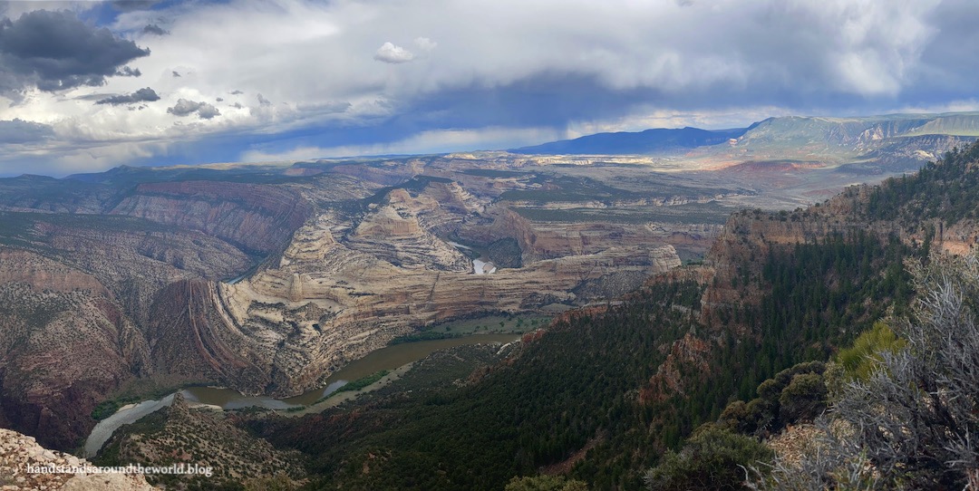
And finally, at the end of Harper’s Corner Road is the hike to Harper’s Corner itself. This is, in my opinion, the best hike we did the entire weekend. It travels about 1.1 miles (1.8 km) each way out to a viewpoint overlooking the Green/Yampa confluence and the extensive expanse of canyons cut by both rivers.
Although we couldn’t see the exact point where the rivers join, this hike made me feel as though we didn’t miss out too much by not driving down to Echo Park.
I meant to do a handstand here, but it was beginning to storm as we arrived at the overlook and in our haste to get back to the car (on an exposed canyon rim is not where you want to be when there’s lightning), I completely forgot.


The tilted rock layers and colorful geology of Dinosaur are on full display here, as you can see in some of the photos above. In fact, the layers are so tilted that the rocks we were standing on here on the Colorado side of the monument – which is about 1000 feet (305 m) higher in elevation – are actually millions of years older than the exposed rocks on the Utah side.
It’s truly spectacular!
The Important Stuff:
- Getting there: The photos and info in this post are from the Colorado entrance to Dinosaur National Monument near the town of Dinosaur. This is the half of the monument without any dinosaur bones.
- Fees and passes: entry to the monument costs $25/car for a 7 day pass; America the Beautiful passes are accepted.
- Where to stay: the only campground in this part of the park is down Echo Park Road and it is primitive; for other lodging, the closest options are on the Utah side of the monument.
- Hiking: there are three hiking trails that depart from Harper’s Corner Road. More info on each hike can be found here.
- Other: although the elevation at Dinosaur is around 5000 feet (1500 m), this is the desert. It’s hot and dry in the summer and cools off quite abruptly at night. Even at the end of May it was about 85°F (29°C) and sunny during the day… later in the summer temperatures regularly exceed 100°F (38°C) so this is a park best visited in the offseason.
Leave a Reply to treksandtorsCancel reply