For our final day in eastern Utah, we headed into the Island in the Sky district of Canyonlands. This is the one you’ve probably seen pictures of, as it’s the easiest to access and therefore the most popular. It’s only about a 40 minute drive from Moab, down a very scenic stretch of highway.


I first visited many years ago with my family and wrote a post about it a while back. But since it was so long after the fact I wasn’t able to provide many details. Now that I’ve re-done all these hikes and the memories are fresh and the photos are better quality, I figured it was a good time to update that post. So here goes…

The Island in the Sky district is traversed by a 17 mile (27.5 km) Y-shaped road. We began by driving to the end of the right prong of the Y for three short hikes. First stop: Upheaval Dome.
Upheaval Dome is probably the most unique geologic feature in Canyonlands. Or anywhere, really. I’ve never encountered anything else quite like it. It’s basically a giant mound of colorful sand inside a large crater. Geologists have proposed two possible explanations for how it formed, though neither has been definitively verified.
Explanation #1 is that Upheaval Dome is a salt dome. A salt dome could have formed when salt – which is less dense than rock – was crushed by layers of sandstone and eventually forced upward. Over thousands of years, the salt continued to be forced up through a crack in the rock, widening it. Simultaneously, erosion wore away the sandstone leaving behind the pile of salt we see today.
Explanation #2 is that Upheaval Dome is the result of a meteorite impact approximately 170 million years ago that formed the crater and exposed the salt buried beneath. Scientists have identified shocked quartz in Upheaval Dome. This type of quartz is known to form only under extreme pressure, such as that provided by a large impact or a nuclear bomb. The presence of shocked quartz supports explanation #2 over explanation #1. Personally, I like #2 better anyway… meteorites are neat!
Unfortunately, the sun was still pretty low in the sky when we arrived at the Upheaval Dome overlooks. From a photography perspective, November isn’t the best time of year to visit Canyonlands. There are just too many shadows in the canyons when the sun isn’t directly overhead. I’ve included a photo from my previous Canyonlands trip below as well; it was taken with a crappy old camera, but at least it isn’t awkwardly shaded.


Next stop, just up the road, was Whale Rock… which does, in fact, look like a giant whale. This was a fun hike, following the cairns up the whale’s back to the hump – which we assume represents the blowhole. We were the only people on the trail this early in the morning, so we got to enjoy the views by ourselves for a while!


Our third short hike was up Aztec Butte. This was the steepest hike of the day, gaining 225 feet (69 m) en route to the top of this feature. The first half of the trail is a sandy walk to the butte, while the second half follows cairns to the top and looks something like this:

The highlights of Aztec Butte are views and Native American ruins. There is one structure atop the butte and a granary built into the side of a rock along the trail. The lack of any permanent structures in this area has led archaeologists to hypothesize that Native Americans traveled through this area but did not live here long term. The lack of water up on the canyon rim also supports that theory. The granary would have been a place for grain storage, thus providing a source of food as people passed through.


This wraps up the right half of the Y-shaped road. Now that the sun was higher in the sky, it was time to head left and see the canyon up close! First stop: Green River Point. There is no hiking here, just a walk-up viewpoint of the Green River half of the canyon, including a glimpse of the river itself. This was the only place we were able to see this river.

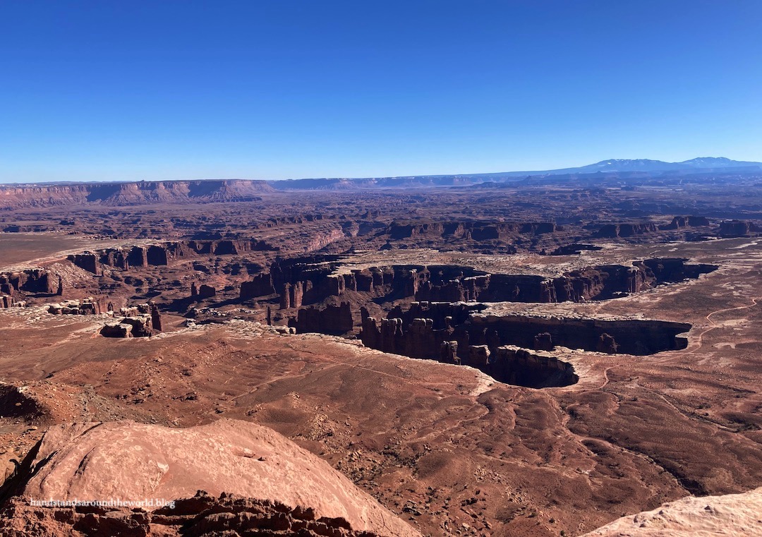
As we made our way down this half of the road we spent a few minutes at each of the viewpoints along the way, enjoying views of the canyon from various angles. The many rock layers were now clearly discernible, and signs at the different viewpoints do a nice job of pointing out which layer is which and all the visible geological features.


All the way at the end of the road is Grandview Point, which can be enjoyed with just a short walk to the edge or expanded to include a relatively flat 2 mile (3.2 km) roundtrip hike along the rim. We opted to complete the hike and eat our lunch at the trail’s end, overlooking the vast red rock expanse.


Now that we’d reached the end of the road we began to slowly make our way back toward the visitor center, stopping at the viewpoints we’d skipped before. We hiked out to White Rim Overlook first. The white rim is the light layer of rock visible in most of these canyon photos. It’s located about 1400 feet (425 m) below the canyon rim, but still nearly 1000 feet (305 m) above the rivers. It’s a more erosion-resistant layer of rock, which has allowed it to endure.


There’s also a road down on the white rim (visible in the photos above), which can be traveled with a 4WD vehicle, dirt bike, or mountain bike, and a permit. We don’t own any of these things, but we did enjoy watching the cars and bikers pass by. There are also two viewpoints from which you can watch people navigate the ascent/descent down Shafer Trail to the White Rim Road. My photos are pretty terrible due to the setting sun, but they do a decent job of depicting the steepness of Shafer Trail.


And finally, that brings us to Mesa Arch. It’s not well known, but Canyonlands is home to a few arches. Most of them are way in the backcountry, but Mesa Arch is just a short hike. The arch faces east and nicely frames not only the canyon and the La Sal Mountains but also the sunrise. Unfortunately, the secret on this one is out; we chatted with a guy who’d been there for sunrise… along with about 50 other people. Knowing this, I firmly stand by our decision to not wake up super early for that experience.
As was the case at Arches, most everyone did a pretty good job of taking turns, staying out of the way of other peoples’ photos, and offering to take photos of each other, which we really appreciated.

And that was our day at Island in the Sky, and the final day of our mini getaway. When we booked this trip, we weren’t even sure we’d end up getting to go. So many things could have gotten in our way… new COVID quarantine rules, snowy roads, awful weather, haze. We were so lucky to have none of the above. In our two days in Canyonlands we saw one cloud.
I’m working on convincing my fiance that Thanksgiving road trip should become an annual tradition. It sure was a perfect time of year to visit the Utah desert!
The Important Stuff:
- Getting there: the Island in the Sky district is located 33 miles (53 km) from Moab, UT on Utah Highway 313.
- Fees & passes: $30 per car for 7 days; America the Beautiful passes are accepted.
- Where to stay: There is a small primitive (no water) campground at Island in the Sky that does not take reservations. There are also some camping options on surrounding BLM land, in Moab, or at the adjacent Dead Horse Point State Park. Also, hotels, cabins, etc. are plentiful in Moab.
- Hiking: We hiked all 6 of the relatively short easy trails in this section; a complete Island in the Sky hiking guide can be found here.
- Other: The most important thing to pay attention to at Island in the Sky is water. It’s available only at the visitor center from March-December; best to come prepared with a giant water jug in the car.
Leave a Reply to travelling_hanCancel reply