The day began in a fairly typical fashion when it comes to hiking in Colorado:
- Wake up stupidly early (4:00am) so we can find a parking spot at the trailhead.
- Arrive at said trailhead very early and claim said parking spot.
- Gear up and start hiking.
Mount Audubon is a 13er located in the Indian Peaks Wilderness of Colorado. To reach the trailhead, one must enter through the gates of Brainard Lake Recreation Area, which is (a) gorgeous, (b) exceptionally popular and crowded, and (c) a fee area. It’s $14 per day unless you have an America the Beautiful Pass, and the trailhead parking lots typically fill by 7:00am even on weekdays. Hence our 4:00am wake-up call.
(Update: for 2024, you’ll also need a timed parking permit to be allowed entry. While permit systems can be annoying, it has eliminated the stress of wondering if there will be a place to park. For this hike, reserve a permit for Mitchell Lake.)

Brainard Lake is one of the first places we visited when we moved to Colorado. It was on that trip, two years earlier, that I first sat on the shore of Blue Lake and looked up at the 13,223 foot (4030 m) Mount Audubon. And it was on that day that I decided I wanted to summit it. Fast forward two years, and it was time to make that goal a reality.
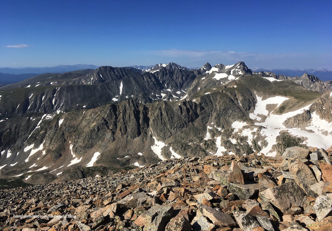
The trail to Mount Audubon begins from the northwest corner of the Mitchell Lake trailhead parking lot and crosses into the Indian Peaks Wilderness just a couple minutes later. The trail climbs gradually through the forest before turning abruptly and curving out and around the lowest reaches of the southeast ridge of Mount Audubon. Then it emerges from the trees and into the tundra.

It was at this point that we were greeted with the first of many views:


From here, the trail turns west and traverses a fairly straight path toward the summit. It’s steep but not prohibitively so, and we did our best to pace ourselves through the next 2 miles (3.2 km) and 1500 feet (460 m) of elevation gain.


The obvious trail ends at a saddle below the summit. From here, the remainder is a steeper climb up the north ridge to the top. Oh and by the way, it’s entirely talus. There are cairns to mark the approximate best route through the jumble of rocks, but it’s largely just a matter of moving in an upward direction.

While wind is always to be expected at this elevation, the Indian Peaks are especially windy and this morning was no exception. Don’t be fooled by the bright blue skies in my photos; the wind whipping up from the other side of the ridge was strong and cold! We’d initially considered crossing the saddle to summit the adjacent Paiute Peak as well, but one gust of that icy wind was enough to change our minds.
From the summit, views were panoramic. To the north was Coney Lake and the rugged peaks of Rocky Mountain National Park. West was Lake Granby, way off in the distance. Southwest was more of the Indian Peaks. And down below to the southeast was Brainard Lake Rec Area. We spent about 20 minutes enjoying our vantage point and refueling while hiding behind a large rock wind block.


It’s when we departed the summit that our day became highly atypical. Before beginning our descent, we walked out to the south edge of the summit in search of some overhead views of Blue Lake.

As we stood there gazing down at it, an idea began to form: what if, instead of hiking back down the trail, we descended to Blue Lake and hiked the Blue Lake Trail back to the car? We were staring down an extensive slope of talus, but the entire route to Blue Lake was visible and it looked doable. No cliffs, no snow, no technical climbing; just a lot of talus. For whatever reason, we both decided this was a good idea… and down we went.


I’m still not entirely sure this should be classified as a “good” idea. The rock was loose in some places, and it definitely took a lot of concentration and careful route finding. It was a relentless test of our leg strength. And it was very slow going; it took us nearly two hours to descend the 1 mile (1.6 km) and 1800 vertical feet (550 m) to Blue Lake.
That being said, I never felt unsafe. It was within our skill level. We stayed far apart – both vertically and horizontally – to avoid sending rocks tumbling into each other, but always within sight so we could keep an eye on each other. And by and large, we had judged the route correctly; no cliffs, no snow, nothing technical, and we were able to remain on our intended path. Plus, these views of Blue Lake are truly one of a kind!


As I sit here writing this the morning after, a large number of my muscles are very unhappy with me. But I’m actually really proud of us. We challenged ourselves, both physically and mentally. We assessed the terrain, found our own route, kept safety at the forefront of our minds, and traversed something that – if you’d asked me even a week earlier – I would’ve snorted and said, “yeah right, we’re not climbing down that.”
That being said, would I do it again? No.
Navigating that much talus is many things, but fun isn’t one of them.

In the aftermath, I think the main lesson we’ve taken away from this is that we’re terrible judges of height. Absolutely terrible. That was the one thing we got completely wrong. We really should have looked at a topo map more closely before making this decision. Blue Lake looked far less than 1800 feet (550 m) below us. I already knew I wasn’t great at judging elevation, but this really reiterated it.
Lesson learned.
And definitely a hike we will never forget.
The Important Stuff:
- Getting there: the Mount Audubon trail departs from the Mitchell Trailhead at the end of Brainard Lake Road, just a few miles outside the tiny town of Ward.
- FFees and passes: there is a $14/day entrance fee to Brainard Lake Rec Area from June-mid Oct (this trail would likely be impassable outside that window anyway); America the Beautiful passes are accepted. You’ll also need a timed-entry parking permit for Mitchell Lake. Permits are released on a rolling basis at 8:00am MDT 15 days in advance.
- Hiking: if you stay on the trail the whole way – unlike us – it’s about 8 miles (12.9 km) round-trip with 2600 feet (790 m) of elevation gain.
- Where to stay: this is an easy day trip from Denver or Boulder. For overnight stays, there is one campground at Brainard Lake Rec Area; reserve in advance, it fills up very quickly. Backpacking is not allowed in this area during the summer.
- Other: If you’re unable to get a parking permit for Mitchell Lake, you can get one for Brainard Lake instead; add 1.4 miles (2.3 km) to the round-trip hike distance.
Leave a Reply to coloradochelseaCancel reply