Mount Rainier is a giant, snow-capped peak located in the Cascade Mountains of Washington state. It rises to 14,410 feet (4392 m) above sea level and, though not the tallest mountain in the continental US, is the most topographically prominent one.
The summit of Mount Rainier is often above the clouds; on a typical day, you’re probably more likely to see it from your flight into Seattle than from the ground. A glance at the peak reveals numerous glaciers and snowfields.
A lesser-known fact, though, is that Mount Rainier is actually an active volcano. Luckily there are no signs of an imminent eruption.
The mountain and surrounding area form the beautiful Mount Rainier National Park, a highlight of the Cascade region. The mountain is encircled by the 93 mile (150 km) Wonderland Trail (it takes 93 miles to get around the mountain – that gives an idea of just how big it is!).
In addition to backpacking this trail and summiting the mountain (neither of which I’ve done, but both of which I want to do), there are many other hiking and sightseeing opportunities in the park. Many summers back, we set out to accomplish some of these.
Our travels began in the southeast corner of the park (it’s relatively a square) at the Ohanapecosh area. There’s a visitor center, picnic area, and campground here.
The name “Ohanapecosh” hails from the Taidnapam Indian language and roughly translates to “standing at the edge.” Ohanapecosh is the lowest elevation section of the park; the weather here is less extreme but the area lacks any sort of view of Mount Rainier.
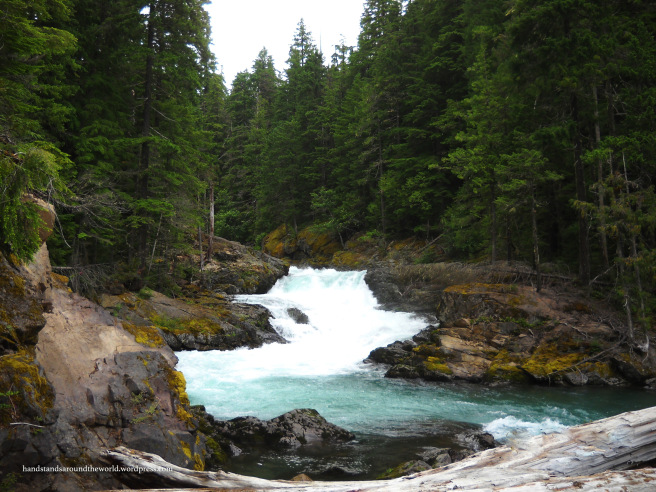
After setting up camp, we took an evening stroll along the Ohanapecosh River to Silver Falls, a relatively easy 1.5 mile (2.4 km) hike from the campground.


We also walked the short nature trail that winds along the edge of the campground, passing by numerous plants with signs identifying them. Since it’s a rainforest, there were a plethora of ferns – which just so happen to be my favorite plant.
Yes, I have a favorite plant.
Even more exciting was a type of fern that I’ve never seen anywhere else – the maidenhair fern! Maidenhair ferns grow in very wet areas and are distinguishable by their black stems, bright green leaves, and fronds that extend from the main stem in a circular pattern.
Needless to say, this is now my favorite type of fern.

We also drove Route 123 up to Chinook Pass and Tipsoo Lake, but found ourselves in fog and unable to see much of anything. However, numerous waterfalls line the roadway and everything was green and full of wildflowers, so if nothing else it was a pretty drive.


And a return trip the following afternoon once the fog cleared revealed the lake (actually, there were two lakes – one on either side of the road) and views from Chinook Pass, so in the end it all worked out.


Next up: our first glimpses of the mountain!
The Important Stuff:
- Getting there: Ohanapecosh is the southeast section of the park. It’s located on WA Highway 123, approximately 35 mins northeast of the town of Randle.
- Fees & passes: $30 per car for a 7-day pass – card only, or pay online in advance. America the Beautiful passes are accepted. Timed entry reservations may be required for some areas of the park.
- Camping: There are multiple campgrounds in Mount Rainier; some accept reservations while others are first-come-first-serve.
- Hiking: The nature trail is a 0.5 mile (0.8 km) loop; Silver Falls is 3 miles (4.8 km) round-trip. Both depart from the campground. See a complete list of hiking trails in the park here.
- Other: though Ohanapecosh is the lowest elevation area of the park, the weather is still variable. It was cool and foggy when we arrived – in late July.
Leave a Reply to sunnydaysinseattleCancel reply