It was the beginning of July and my husband had a couple days off, so we decided we’d take advantage of the opportunity for a mid-week hike at a trailhead that’s typically far too crowded on weekends.
I, of course, already had a list of hikes that fit the bill, but some research revealed most of them were still too snowy. From recent reviews, though, the Arapaho Pass Trail to Lake Dorothy was snow-free and the lake was mostly melted out.
Perfect! It’s a hike I’d been wanting to do for two years now, ever since I glimpsed Lake Dorothy from the summit of South Arapaho Peak.
We arrived at 4th of July Trailhead on, amusingly, July 3rd. The trailhead is located at the end of 4th of July Road, west of Nederland and Eldora. It’s a dirt road with potholes and rocks; we navigated it in our Subaru without issue, but it would have been very challenging – and very slow-going – in a lower clearance vehicle.
Our 6:30am arrival proved plenty early to secure parking, but the main lot and almost all the overflow was completely full by the time we returned, and this was just a random Wednesday. Legal parking spots are very clearly marked, and they do ticket people parked illegally. Also, some of the overflow parking is almost 1 mile (1.6 km) down the road, so it can add a substantial distance to your hike.
We set off up the trail, the first two-thirds of which I’ve written about before; you can read those details in this post. The trail wasn’t quite as wet and muddy this time around, but the waterfall crossing was still a bit sketchy, and I was grateful for my hiking poles and waterproof boots.


On my previous hike, I turned right at the junction near treeline and continued on the Arapaho Glacier Trail. This time, we continued straight at the junction, following signs toward Arapaho Pass. We’d gained around 1000 feet (305 m) of elevation during these first 2 miles (3.2 km), and we had about 1.5 miles (2.4 km) and 900 feet (275 m) to go.

And thanks to our midweek early morning start, up to this point we hadn’t seen a soul. Even now, there was just one person visible in the distance, far above us. We eventually crossed paths with him and a couple others as we continued toward the pass, following the trail across the slope of the mountain peak to the north. It’s mostly talus, but there’s a clear path through with mostly solid footing.

Arapaho Pass sits just shy of 12,000 feet (3660 m) of elevation. We’d been somewhat protected from the wind by the surrounding terrain, but that was no longer the case once we reached the pass, particularly when we wandered out to the edge for a better view down toward Caribou Lake. You can hear it in the video below.

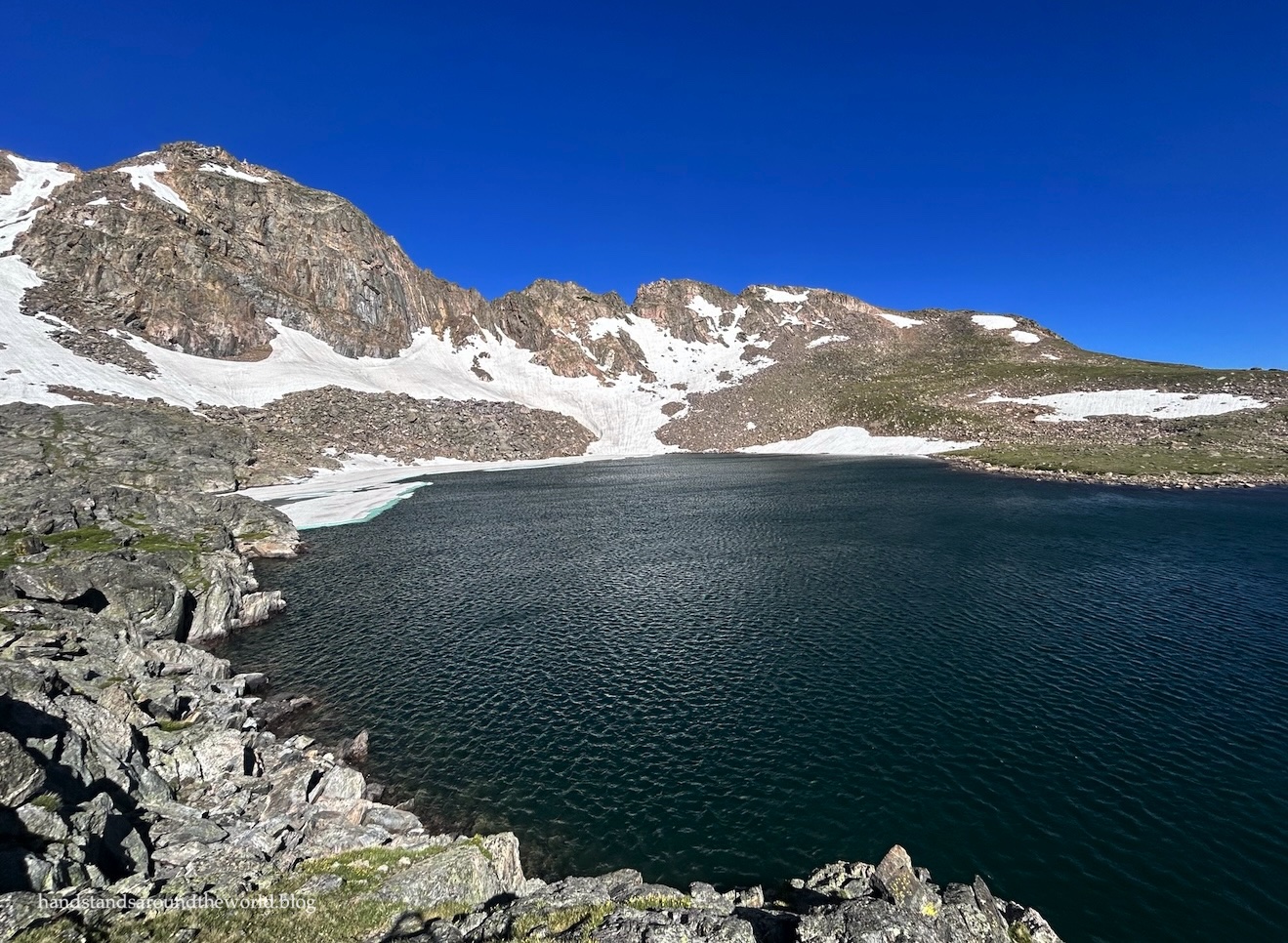
While one branch of the trail continues from here down to Caribou Lake, we headed in the opposite direction, following signs for Caribou Pass. But that wasn’t our destination either. We would promptly be branching off to the left toward Lake Dorothy. This trail is, admittedly, not easy to follow, and we ended up taking the lower branch up to the lake and the upper branch on the way back. The upper seemed easier and more visible, but both will get you up and over the small rise and into the large bowl at the base of Mount Neva.

For a high elevation lake, Dorothy is fairly large. It was mostly thawed out, but a small section of ice remained on the opposite shore, which was more easily visible from the hillside to the south. We took turns climbing partway up it for a better vantage point. However, we spent most of our time down at the lakeshore, sheltered from the wind by a large boulder.


We even had the lake entirely to ourselves for the 30 minute duration of our visit!
The trail was somewhat busier during the descent, though a comparison of the number of people we encountered vs. the number of cars in the parking lot suggests that a majority of hikers opt for the easier Diamond Lake Trail, which splits off not far past the trailhead.

Depending on winter snowfall and spring temperatures, the beginning of July may be a bit early for wildflowers, and that was the case for us this year. I’d estimate we were 2-3 weeks before peak. However, we still saw quite a few along the way, a reminder that summer had finally made it to the Colorado mountains.


A summer which – if all went according to plan – was just getting started!
Up next: visiting New Mexico’s Chaco Culture National Historical Park
The Important Stuff:
- Getting there: 4th of July Trailhead is located at the end of 4th of July Road, west of Nederland and Eldora, Colorado. As of July 2024, some clearance is necessary but 4WD is not. However, check conditions before setting out because sometimes the road deteriorates. Also, arrive very early, especially on weekends, and be sure to park only in marked spots to avoid getting a ticket.
- Fees and passes: none for day use.
- Hiking: round trip distance is 7.5 miles (12 km) with about 2000 feet (610 m) of elevation gain.
- Where to stay: there are a few spots for dispersed camping near the trailhead only. Much of the land along the road is private, so be sure to abide by posted signs to avoid trespassing. Backpacking is allowed, but you must reserve a permit in advance for the Neva backcountry zone (map). With an early start, this can also also be done as a day hike from Denver, Boulder, Nederland, and the surrounding area.
- Other: early in the season or after recent rains, the waterfall crossing may be treacherous; I recommend waterproof footwear and hiking poles. Even with less water than I’ve seen in the past, quite a few people were struggling to make it across without poles.
Leave a Reply