August was rapidly approaching and, with it, a fairly intense backpacking trip at high elevation. Hence the two posts in a row about summiting mountains… and the two others that will be coming soon. This was my attempt to regain all the acclimation I lost when I had Covid and whip myself into shape for my upcoming trips. And, you know, do some hiking.
Colorado has over 500 13ers, and I’m not particularly picky about which ones I summit. Chelsea, however, is working her way through them in a somewhat more goal-oriented fashion, so she always has a long list to choose from.
On this particular day, we chose Mount Guyot; a fairly short hike we could squeeze in first thing in the morning before weather and other plans.
Mount Guyot (pronounced ‘guy-oh’) is located in the Front Range of the Colorado Rockies, not far east of Breckenridge. The mountain can be accessed from that side, and also from the north if you have 4WD, but we went in from the east at Georgia Pass via Michigan Creek Road. As of July 2022, Michigan Creek Road is bumpy in places, but easily passable with a Subaru. Someone even managed to get their sedan up it.
Of course, could and should are two different things, and I personally wouldn’t drive my sedan up that road.
Also, watch for moose… we came around a curve to find a mama and baby standing in the road.
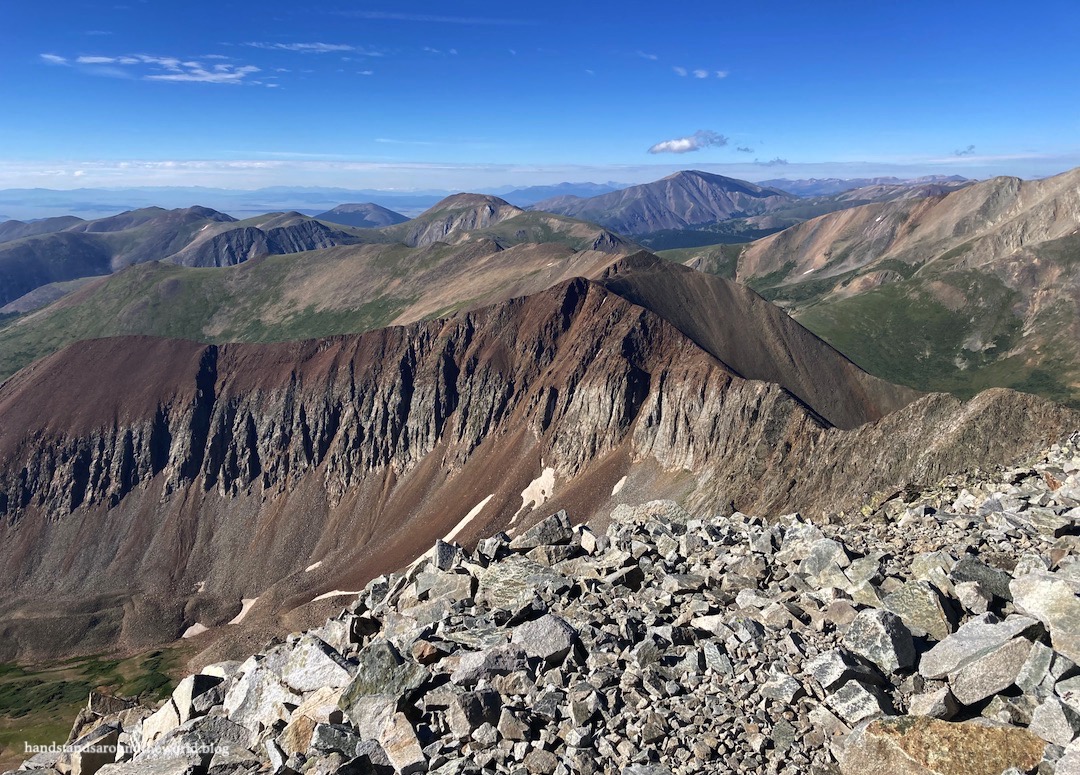
Georgia Pass sits on the Continental Divide at an elevation of 11,585 feet (3531 m). From here, Mount Guyot rises about 1800 feet (549 m) above. From certain angles, it’s a rather pyramid-shaped mountain. Indeed, we would be following a pretty straight ridge all the way to the summit.


We parked near the Continental Divide sign and set off up a short road through the trees and into a grassy area. It doesn’t last long, though. All too soon, we were staring up at an endless expanse of talus. It’s the landscape that would define the entire rest of our hike. Rocks, rocks, and more rocks. Thankfully not too loose.
Nonetheless, this wasn’t my favorite hike ever. Navigating talus takes forever and it’s hard on the feet and ankles. Despite being just a 3.1 mile (5 km) round trip hike, my ankles were very sore by the end.


There were some highlights, though. The first was the view from the 13,370 feet (4075 m) summit, expansive and panoramic. I especially enjoyed the sheer ridge to the south.


The second was the mountain goats. We saw eleven of them, including some up close. Four were babies, and they were so stinking cute! One of the adult mountain goats seemed to think he was king of the trail. He would walk along it, then stop on a high point and take in his surroundings… and cautiously observe us. We named him Gomez.

The descent took the same amount of time as the ascent, thanks to the talus. Fortunately, we’d started early and there were no storms to worry about. By the time we returned to the car, there were a few other people recreating at Georgia Pass. However, we were the only ones to have summitted Mount Guyot that morning, which is pretty neat.
Up next: a somewhat less intense hike to a beautiful alpine lake. Stay tuned!
The Important Stuff:
- Getting there: Georgia Pass is accessed from Michigan Creek Road (Co Route 35, then 54) at Jefferson, Colorado. Easily passable in a Subaru, possibly passable in a sedan if the road is dry.
- Fees and passes: none.
- Hiking: from Georgia Pass, we clocked the round trip at 3.1 miles (5 km) with 1726 feet (526 m) of elevation gain, most of which is on talus.
- Where to stay: there are multiple dispersed campsites and established campgrounds along Michigan Creek Road, as well as overnight lodging in Fairplay, Bailey, and, of course, the Front Range. In addition, Mount Guyot can be reached from Breckenridge and surrounding towns in Summit County, though not from the route we took.
- Other: be ready for lots and lots and lots of rock. Sturdy shoes/boots, hiking poles, and gloves may all be useful to navigate the extensive talus. Also, please don’t approach the mountain goats.
Leave a Reply to ourcrossingsCancel reply