Most people who visit Colorado in search of mountains go to Rocky Mountain National Park.
Don’t get me wrong; Rocky is incredible and well worth the trip. But there are so many other equally stunning areas of the state.
Exhibit A: the Indian Peaks Wilderness just south of Rocky.
Over the last four years, I’ve done numerous hikes in the Indian Peaks. And there are still dozens more I’d like to do. At the end of July, I completed one of these with my friend.
Our day began far too early, when we reluctantly rolled out of bed (thank goodness she never minds when I crash at her place the night before a hike… otherwise I would have needed to wake up an hour earlier, which I absolutely refuse to do). It was still dark when we set off for 4th of July Trailhead.
The last 3.5 miles (5.6 km) of the journey is on a dirt road that is passable with a little bit of clearance. I wouldn’t take a sedan up it, but we did just fine in a Subaru.
We arrived to find plenty of parking… but it was a Wednesday. Weekends at this trailhead are ridiculous. Don’t expect to find parking if you arrive after about 6:00-6:30am. Note also that allowable parking spots are very clearly marked, and they will ticket you if you park illegally.
Anyway. We headed off, following signs toward Arapaho Pass and Arapaho Glacier. The trail begins in fairly typical Colorado fashion: dirt, roots, rocks, and a steady uphill climb through the forest. Occasionally, the trees would part and we would catch glimpses of the surrounding mountains. As we gained elevation, the trees were gradually replaced by wide open meadows and wildflowers. Thousands and thousands of wildflowers.


Also, there was so much water and mud. We navigated multiple creek crossings, two extremely muddy sections, and a couple spots where the creek and the trail appeared to be one in the same. I was glad to be wearing waterproof boots and ankle gaiters.


At one point, we ended up on a path that didn’t seem to be the actual trail. I went back to look, but couldn’t figure out where we’d gone wrong. There was no other visible path. How could we have missed it? Well…

After approximately 2.5 miles (4 km) of dirt and rocks and water and mud, we reached a fork in the trail and followed signs to the right toward Arapaho Pass. We were mostly above tree line now; a few short, stubby pines and some willow bushes covered the landscape, but the scenery was wide open and we could see where we were headed. It was quite a ways up still.

What we couldn’t see, as it turned out, were the moose. There was a mama, baby, and male not far from the trail. I’m very grateful to the woman ahead of us who warned us of their presence… especially since we had my friend’s dogs with us. They were leashed, but one was pretty new to hiking at the time and we didn’t know how he’d react.
And, after some scary human-moose encounters in the past, moose make me very nervous. Fortunately, they were moving away from the trail, and the woman eventually motioned to us that we were okay to proceed.
Later, we looked down on the trail from above and saw all three moose far below. We’d also seen three moose along the road on the drive to the trailhead, bringing our total for the day to six. It appears that my uncanny ability to attract moose is not going away any time soon.
(Seriously… this has become a thing. People have started making fun of me over the number of moose I see.)

Once safely past the moose, we continued our ascent toward South Arapaho Peak. While the hike to this point had been somewhat gradual, this section was steeper. And overflowing with even more wildflowers.


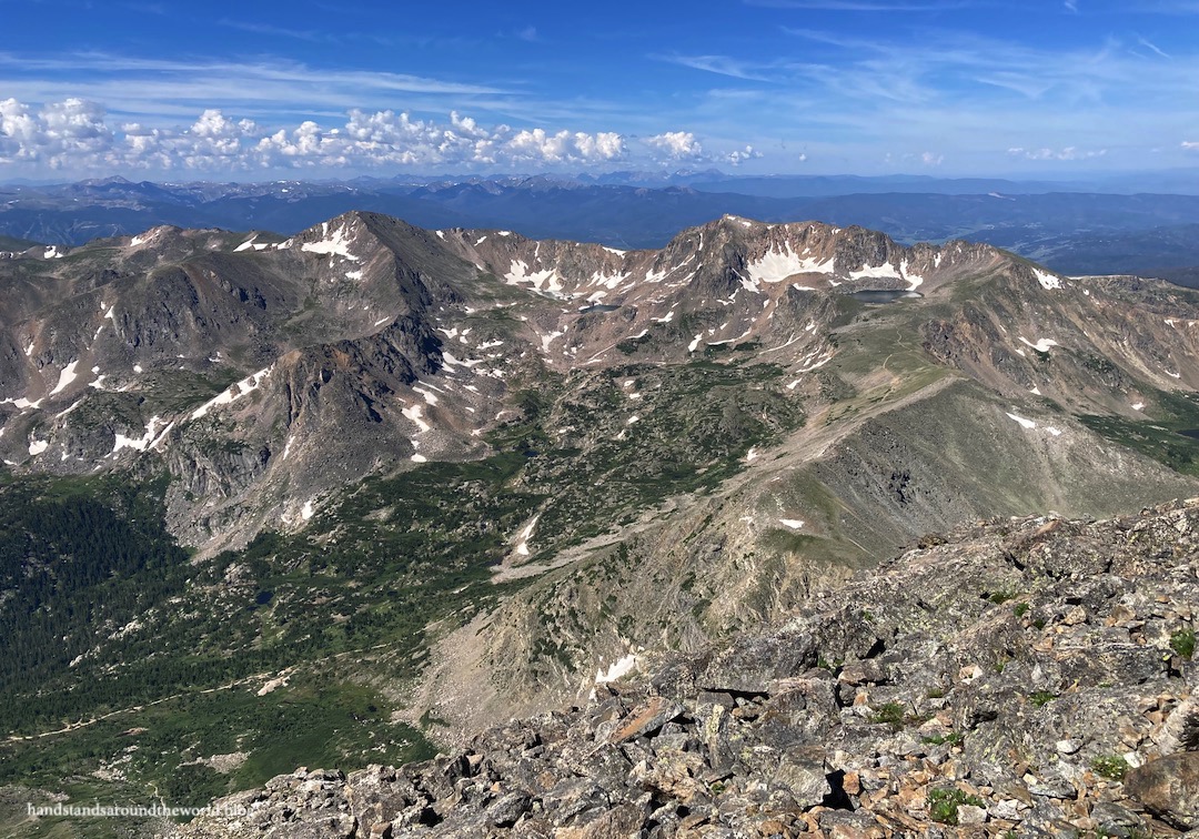
Eventually, we reached the saddle between South Arapaho Peak (to the west) and a point called Old Baldy (to the east). We stopped here to eat a snack… and enjoy the view of Arapaho Glacier. Like all “glaciers” in Colorado, this one is really just a semi-permanent snowfield and is relatively small. But the turquoise tarn at the base is really pretty!


The steepest part of our hike, though, was yet to come; we still had to climb 650 feet (200 m) over a jumbled pile of rocks to reach the summit.
At this point, I was wishing we didn’t have the dogs with us. They both did great; they’re very agile and we knew they could make it, which is why we brought them. But in general, I wouldn’t recommend bringing dogs on this hike, not only because some might not be able to navigate the rocks, but also because climbing over rocks while holding a leash can be awkward (and it’s a wilderness area, so leashes are required).


But we did it, and the dogs did it, and soon we were standing on the summit gazing out in all directions. It was stunning! I’ve heard people characterize this as their favorite hike in the Indian Peaks, and I can certainly see why.


The Important Stuff:
- Getting there: 4th of July Trailhead is located at the end of 4th of July Road, west of Nederland and Eldora, Colorado. As of July 2022, some clearance is necessary but 4WD is not. However, check conditions before setting out because sometimes the road deteriorates. Also, arrive very early, especially on weekends, and be sure to park only in marked spots to avoid getting a ticket.
- Fees and passes: none for day use.
- Hiking: round trip to the summit of South Arapaho Peak from 4th of July trailhead is 9 miles (14.5 km) with 3330 feet (1015 m) of elevation gain. The final stretch to the summit is class 2 and may not be suitable for many dogs or for people who are uncomfortable with scrambling.
- Where to stay: there are a few spots for dispersed camping near the trailhead only. Much of the land along the road is private, so be sure to abide by posted signs to avoid trespassing. Backpacking is allowed, but you must reserve a permit in advance for the Neva backcountry zone (map). With an early start, this can also also be done as a day hike from Denver, Boulder, Nederland, and the surrounding area.
- Other: the final climb to the summit is slow going because of the rocks, and descending this section takes almost as long as the ascent. Keep a close eye on the weather, and be sure to leave yourself adequate time to descend below tree line before storms arrive.
Leave a Reply to runningtotravelCancel reply