Sometimes, a hike ends up being more laid back than you thought it would be and goes more quickly than you expected.
And sometimes, a hike is far more intense than you anticipated and it takes 8 hours to hike 7 miles (11.3 km). This hike was one of the latter.
Chelsea and I set out fairly early for a three-13ers-in-one-day type of adventure. The first of its kind for me, as I’d never before summited three mountains in the same day. But before we could begin climbing mountains, we first had to make it to the trailhead… a task that was also more challenging than we expected.
We were planning to begin our hike at Fall River Reservoir, which is at the end of a 3 mile (5 km) very rough road. I would have taken one look at the many rocks and bumps and assumed it wasn’t possible to get to the trailhead without 4WD and a lot of clearance. But Chelsea is a much more experienced driver than I am on roads like this and, as it turns out, it is possible to get a Subaru all the way to Fall River Reservoir.
It was very slow going. But we did it.
And by ‘we’ I mean ‘she,’ as I mostly just sat there.
Anyway. We reached the trailhead and set off on our hike. I use the word ‘trailhead’ very loosely… after all, is it technically a trailhead when there isn’t really a trail?

Unlike Colorado’s 14ers, which are climbed regularly by thousands of people, most of the state’s 13ers fly under the radar. As a result, there are often no established trails. Chelsea had a copy of a previous hiker’s route that gave us an approximation of where to go, but the specific details were up to us.
Step one was to gain the ridge. So up we went, bushwhacking our way through the forest and doing our best to find the least challenging route. It actually wasn’t too terrible; there wasn’t a ton of underbrush so we didn’t have too much trouble making it through.

Once we cleared the trees, navigation was much simpler. We still had a lot of climbing to do to reach the ridge… but at least we weren’t bushwhacking anymore. It was a very challenging and slow first mile.
By the time we reached Mount Bancroft’s southeast ridge, the steepest part of the hike was over. We still had a ways to go to reach the summit, though. As we gained elevation we were able to see down into the adjacent valley, home to Loch Lomond Reservoir and Lake Caroline. I’ve hiked to Loch Lomond before, so it was neat to see it from above.


Finally, 4 hours after setting out, we reached 13,250 feet (4040 m) and the summit of Mount Bancroft. Technically, Bancroft is not considered its own mountain; as it rises only about 250 feet (76 m) above the saddle with adjacent Parry Peak, it is instead considered a sub-peak of Parry. I’m choosing to ignore that classification and calling it summit 1 of 3 for the day.


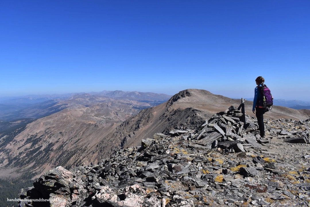
From Mount Bancroft we descended to the saddle, staying to the left of the two little bumps to avoid having to climb up and over them. At times there was a vague trail, but route-finding was not difficult. From the lowest point of the saddle, it was just shy of 400 feet (122 m) up to the summit of 13,391 foot (4081 m) Parry Peak.


From Parry Peak, located on the Continental Divide, we could now see west toward Berthoud Pass and Winter Park ski resort. The summit was windy, but a wind block provided us with some shelter. Once out of the wind, it was actually pretty perfect summit weather; sunny and warm, with good visibility and no incoming storm clouds. We hung out here for quite a while.


But we still had one more peak to go, so eventually we built up the motivation for the trek across to 13,130 foot (4002 m) Mount Eva – the lowest of the three summits. As before, there was no trail. We simply descended to the saddle, staying to the west of the ridge. The last few hundred feet to the Mount Eva summit was the rockiest portion of the hike; it slowed us down a little but never exceeded class two.


The summit of Mount Eva is home to a radio tower that has collapsed, presumably due to wind. Winter winds in the Colorado Rockies can be absurdly strong. Nonetheless, it’s difficult to wrap my head around wind being so strong that it can uproot a large metal and concrete structure.


From Mount Eva, it was time to begin the descent. I think it was here that we realized this hike was going to take us far longer than we anticipated. The entire descent was off-trail as well; we dropped down the south ridge of Mount Eva toward the saddle, staying above what appeared to be a steep rocky section (which turned out to not be so steep after all) and aiming for the grassier terrain. We cut somewhat of a diagonal path down into the basin, heading for the opposite side which would allow us to avoid the large collection of willows.


Our target was Upper Chinns Reservoir, also known as Sherwin Lake. We could see it off in the distance and aimed for it as best we could, but it was surrounded by trees which meant more bushwhacking. Once we were in the trees, it was more difficult to maintain a straight path. We also had lots of rock outcroppings to navigate. In a couple spots it took a little bit of trial and error to find the best way through. But eventually the water came into view through the trees and we reached the shoreline.

The water level was extremely low, which worked to our favor because we were able to walk along the shore rather than find our way through more trees. From the opposite side of the reservoir we caught up with Chinns Lake Road, following it around Lower Chinns Reservoir.


But we weren’t quite done, as we’d parked at Fall River Reservoir which was down the hill to the north. And no, there’s not a trail between the two. We did find a very vague path through the trees, which was a welcome sight; we were beyond tired of bushwhacking.

And finally, eight hours after departing and thoroughly exhausted, we arrived back at the car.

The Important Stuff
- Getting there: we began our hike at Fall River Reservoir, located at the end of Fall River Road near Alice, Colorado; at minimum, you need a Subaru to reach the reservoir. High clearance 4WD with larger tires would make for a quicker and less bumpy drive.
- Fees and passes: none.
- Hiking: we were essentially off-trail and route finding for this entire hike; for us it was 7 miles (11.3 km) roundtrip with 3260 feet (995 m) elevation gain, but exact distances will vary depending on your chosen route.
- Where to stay: the trailhead is close enough to the Front Range for this to be a day trip; however, numerous (very popular) dispersed campsites exist around Fall River and Chinns Reservoirs for those looking to make it an overnight trip. Beware that there is a lot of private property in the area; failure to obey ‘no camping’ and ‘no parking’ signs will result in a hefty fine.
- Other: we were above tree line for over 6 hours on this hike. I wouldn’t have attempted it earlier in the season when thunderstorm risk is higher due to the lack of shelter and relatively few options for bailing out early if a storm rolled in. Late September was a good time of year for this one; no snow yet but also no storms.
Leave a Reply