
It’s taken me a long time to get around to writing about Colorado’s State Parks. This is partially because we’ve yet to purchase a State Parks pass so they aren’t common destinations for us. The second reason is because I’ve been holding off on these posts until I’ve done a decent amount of exploring at each park.
Thanks to Chelsea and her State Parks pass, I was able to visit Roxborough State Park for the first time ever this past winter when she and I climbed Carpenter Peak as an 8.6 mile (13.8 km) loop hike. A month or so later, Pat and I headed out one Sunday afternoon to visit Roxborough for their Trail of Lights. We arrived shortly before sunset to tour the visitor center and hike the Fountain Valley Loop trail as well. Altogether, I’ve now seen a fairly substantial portion of this somewhat small park.
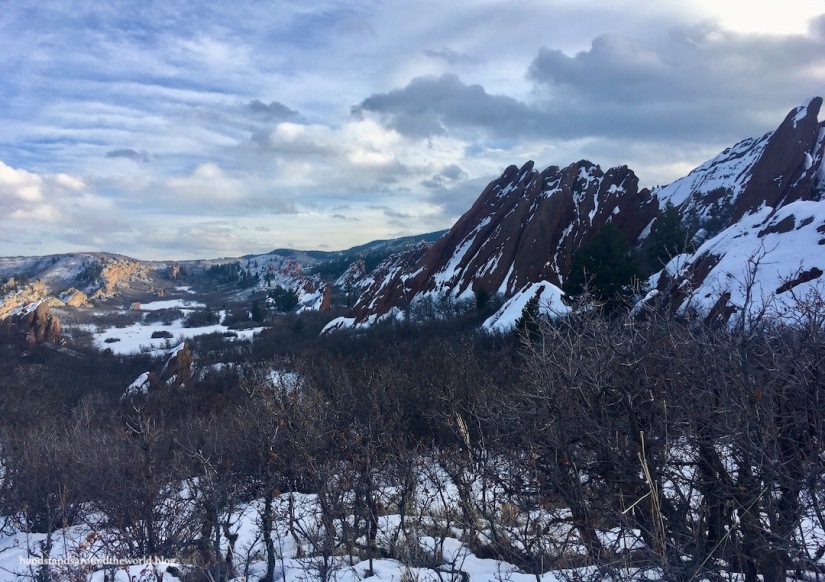
What Roxborough lacks in size, it more than makes up for with its dramatic landscape. The large, angular, iconic red rock fins that make Roxborough such a popular destination are actually part of the same rock formation that’s seen at Garden of the Gods in Colorado Springs and Red Rocks Amphitheater west of Denver. This same layer is also visible further north as the Flatiron Mountains of Boulder.

The Fountain Formation, as it’s called, is a layer of red sandstone that was deposited nearly 300 million years ago, uplifted, and subsequently exposed by erosion. The high concentration of the pink mineral feldspar contributes to the color of the formation, while the darker bands of color are due to oxidized iron. An interesting – and somewhat unusual – fact about this formation is that the rocks immediately beneath are 1.7 billion years old, meaning approximately 1.4 billion years of geologic history is missing from this area of the Front Range. This indicates that whatever happened during that time was eroded away before the Fountain Formation was deposited.
Behind the exposed rock fins at Roxborough is a hogback: a narrow ridge with steep but similarly inclined slopes on both sides. The highest point on this hogback is Carpenter Peak. This was our destination for the day.
The Carpenter Peak trail is the longest and most difficult hike in the park, meaning it’s also the least traveled. We went on a Tuesday and saw almost no one else, but I suspect weekends are substantially busier since this park is on the outskirts of Denver. The hike begins from the visitor center on the Willow Creek Trail, which connects with the Carpenter Peak trail after about 0.6 miles (1 km). From here, the trail becomes steeper as it zigzags up the front of the hogback. The trail then curves north and winds up and down along the ridge before finally reaching Carpenter Peak.


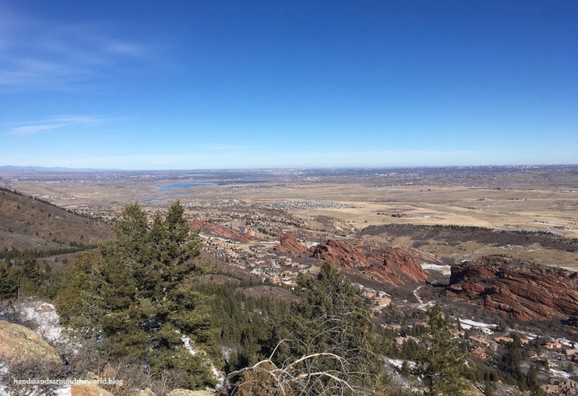

As Carpenter Peak is the highest point in the park, we had 360° views from here.

The most common way to finish this hike is to return via the same path, but we decided to take the alternate route. At the first junction just below the summit, we turned right onto the Carpenter Spur which descended fairly steeply to the Powerline trail. This trail undulates across the back side of Carpenter Peak for about 1.8 miles (2.9 km) before connecting with the Elk Valley trail. While relatively untraveled and peaceful, this route had more ups and downs than we expected and our legs were not pleased. But we distracted ourselves with the various animal tracks in the snow and a large group of deer in the distance and eventually we reached the Carpenter Peak trail once more, which meant it was all downhill back to the parking lot!
In contrast, the Fountain Valley Loop is a fairly flat 2.3 mile (3.7 km) loop trail that weaves in amongst the red rock formations and climbs slightly to a couple viewpoints, providing a very different perspective of the park. Pat and I really enjoyed this leisurely late-afternoon stroll and the many colorful, snow-covered views it provided.


This trail also passes the old Persse house and cabins. Henry Persse moved to Denver from New York in 1888 and became co-owner of the land that is now Roxborough State Park. At the time it was called Washington Park, after a giant rock that supposedly looked like George Washington. We couldn’t find the rock, but the photos of it on the sign looked absolutely nothing like Washington… or any other person, for that matter.
Persse ultimately renamed the land, inspired by his Irish heritage. He built a house and other buildings here for himself in 1903 but his eventual goal was to turn this area into a resort. This never came to fruition and about 15 years later he was hit and killed by a streetcar. His house and two of the cabins still stand today, and this land he cherished is now preserved for years to come.


And lastly, the Trail of Lights, which apparently takes place every January and February and stretches from the parking area to the visitor center. That sounds a lot more impressive than it actually was. It’s a few strands of twinkling lights wrapped around some trees and draped over the sidewalk, forming a “trail” that takes less than 1 minute to walk along. The main purpose is really just to encourage visitors to come to the park after dark for some night hiking and stargazing. But it was Sunday evening and we had to work in the morning and we’ve both stargazed before in places with far less light pollution, so we didn’t stick around very long after sunset.

Aside from the disappointment of the Trail of Lights, it’s certainly easy to see why Roxborough is such a popular park. It’s a quick trip from Denver, full of colorful geology, and definitely worth a visit!
The Important Stuff:
- Getting there: Roxborough State Park is just a few minutes south of Highway 121 in Littleton, Colorado
- Fees and passes: $8/car for a day pass, or $80 for an annual Colorado State Parks Pass, which can be purchased at the entrance station
- Hiking: there are a total of 8 trails in the park of varying lengths and difficulty levels; some can be combined to form a longer loop hikes (park map and info here)
- Where to stay: there is no camping or lodging in the park, but the park is on the outskirts of the Denver metro area so there are plenty of options nearby
- Other: unlike most other state parks in Colorado, dogs and bicycles are not permitted here

Another great CO find!
LikeLiked by 1 person
Every time I read one of your posts, I’m itching to go and explore Colorado. What incredible variety and quantity of hiking opportunities. I especially like the snow-dappled views from Carpenter Peak.
LikeLiked by 1 person
Great info! I need to get back and finish up the lower trails this winter
LikeLiked by 1 person
Another lovely spot in Colorado! Even if the Trail of Lights was just a brief stroll, the photo of it looks really pretty, and it’d get me to visit the state park! The geology of Roxborough looks unique, especially capped with snow, and I hope to check it out some day should I return to Colorado. Thanks for sharing, Diana!
LikeLiked by 1 person
Besides the great photos, thanks for the geology lesson. Very clear and interesting.
LikeLiked by 1 person