
It only takes a few minutes of researching ‘best things to do in Colorado’ – or some form of that sentence – before the Million Dollar Highway turns up. This 23 mile (37 km) section of Highway 550 stretches from Ouray to Silverton, and it’s iconic for a reason. The views are indescribable, the steep grades and sharp curves cannot be overstated, and there is an obvious lack of guard rails despite the narrow lanes and abrupt drop offs.
That being said, the Million Dollar Highway is only a small section of the 232 mile (373 km) San Juan Skyway Scenic Byway and, while it receives all the attention, we drove about 190 miles (306 km) of the Skyway and I highly recommend all of it!
In addition to views, there’s also a tremendous amount of history in this area in terms of railroads, mining, and even electricity. Much of the Skyway follows the route of the historic narrow gauge Rio Grande Southern Railroad, while the old Ames Power Plant – which is visible from the highway – is the site of the first successful use of an alternating current (AC) electrical system.
We began our Skyway drive on US 160 in Durango, heading west to Mesa Verde National Park which I’ve blogged about for the last couple weeks. At the end of our time in the park, we headed west to the city of Cortez (a good place to resupply on gas, ice, and groceries) and then turned north on CO Highway 145 toward the beautiful towns of Mountain Village and Telluride.


Arguably the biggest attraction in Mountain Village is the free gondola ride up to the top of the ridge and over into Telluride. It’s the only free gondola of its type in the US and it’s run entirely on wind and solar power. Parking is also free in the Mountain Village Gondola Garage.


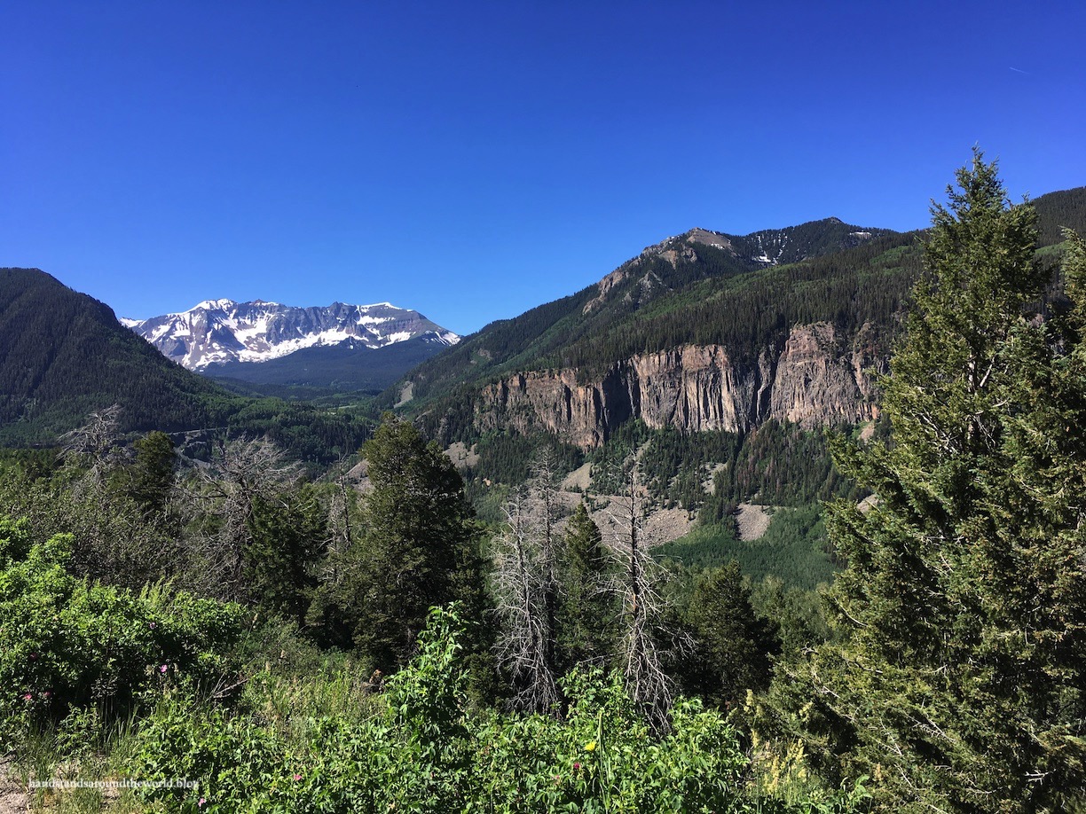
I remember seeing a photo of Telluride on Instagram a couple years back and assuming it was somewhere in Switzerland. The nearby town of Ouray (pronounced ‘you-ray’) is actually affectionately known as the Switzerland of America, but I personally found Telluride to be more scenic and Switzerland-esque.

Pat and I really, really loved Telluride. It’s a ski town, but we found it to be quaint and quiet despite being the height of summer tourist season. I’m sure it’s busy at times, but on this particular sunny Tuesday we enjoyed a non-crowded walk through the streets and some beers and amazingly delicious sweet potato fries at Smugglers Brew Pub.


Telluride is also home to the tallest single-drop waterfall in Colorado: Bridal Veil Falls. It’s 365 feet (111 m) tall and is fairly easy to visit. If you have a high-clearance car you can drive all the way to the base of the falls. If you don’t, you can park about 1.2 miles (2 km) down the road and hike up. We probably could have made it up with our Forester, but there was one section that would have been a little sketchy and we didn’t really want to put the wear and tear on our car. So we walked the numerous switchbacks up the hill to the base of the falls, and it was a steady incline but a nice hike.
As we hiked, we saw a handful of other waterfalls tumbling down the surrounding mountainsides. We also navigated a shallow creek crossing and the remnants of numerous avalanches. This area of the state in particular got slammed in winter 2019. Snowpack in the San Juan Mountains was 1200% of normal (no, I didn’t accidentally put an extra 0 there!), resulting in a huge amount of road and trail damage. In fact, we hadn’t initially planned to visit Telluride at all on this trip, but snow, ice, and avalanche debris rendered our two planned hikes inaccessible so we had a last minute change of plans.


 Anyway, we reached the base of Bridal Veil Falls and proceeded to get completely drenched in about 30 seconds! The volume of water was truly astounding and it was impossible to find a place to view the falls without getting soaked.
After falling in love with Telluride – and promising ourselves we’d return someday soon – we continued our northward journey on the San Juan Skyway, following Highway 145 to Highway 62, which turns northeast and heads to Ridgway.

From here, the Skyway turns south on US 550 toward Ouray. Ouray is a popular destination for everything from ice climbing to hot springs to high altitude endurance races. If you’re looking for some less intense and/or free things to do, I recommend the 6 mile (9.6 km) Ouray Perimeter Trail which – as the name suggests – encircles Ouray. This is widely accepted as one of the best trails in the area, and I’ll be devoting an entire post to it next week!
We enjoyed some beer and pretzel bites with beer mustard and beer cheese on the rooftop balcony of Ouray Brewing Company after our hike.


And finally… we’ve reached the famous Million Dollar Highway, which begins abruptly from the southern edge of Ouray. Pat is a very careful driver; nevertheless, being in the passenger seat with just a few feet separating me from certain death by sliding off a cliff was definitely nervewracking. If just looking at the photos below makes your heart race and your palms sweaty, this may not be the drive for you.


On the other hand, if views like this look like something you want to see through your windshield, this is absolutely the drive for you!

Though it’s only 23 miles (37 km), plan at least an hour to drive this section of road; in addition to the slow speed limits and white-knuckle driving and inevitable getting-stuck-behind-a-giant-semi, you’ll also want to stop at all the pullouts to enjoy the incredible views.


There are many theories as to the origin of the name Million Dollar Highway. Two theories have to do with the cost of building the road. A third theory states that the name comes from the millions of dollars of precious metals in the region or, more specifically, within the dirt used to build the road. An additional theory has the name stemming from the million dollar views one encounters all along this stretch of road.
I have no idea which theory is correct – no one seems to – but I certainly can’t argue with the million dollar views one. Theory #3 seems reasonable as well, given that this region once contained six mining settlements that produced $250 million in metal ore!
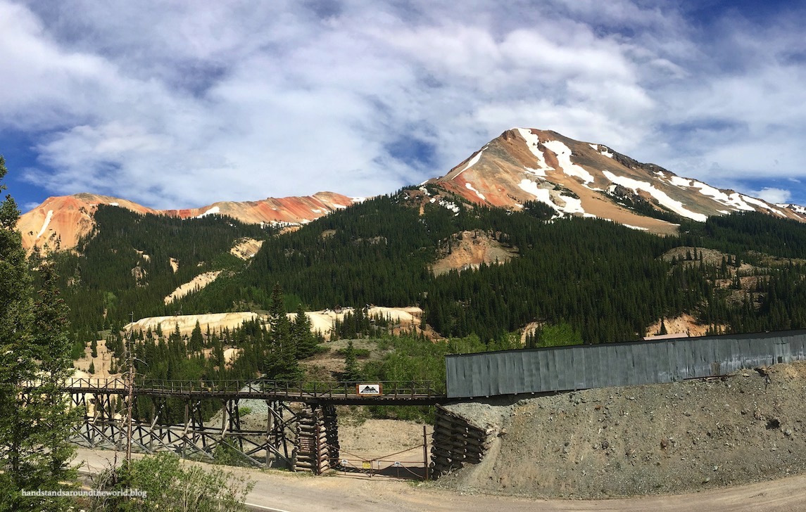
We ended up driving the Million Dollar Highway four times – twice in each direction – and Pat and I agree that starting in Ouray and ending in Silverton is the way to go. From Ouray it’s 13 miles (21 km) and 3300 vertical feet (1006 m) up to the high point at Red Mountain Pass – which tops out at 11,008 feet (3355 m) – and 10 miles (16 km) and 1500 vertical feet (460 m) down into Silverton. The first few miles after Ouray, though, are the most treacherous part. The curves are tight, the grades are steep, and there isn’t much of a shoulder; this is the reasoning behind Pat’s recommendation. He says he preferred driving steeply up out of Ouray than dropping down into it.
Personally, I recommend going from Ouray to Silverton for purposes of scenery. Though it’s all scenic, the highlight for me was the last few miles up to Red Mountain Pass from the Ouray side.


The Million Dollar Highway ends in the old mining town of Silverton, though the San Juan Skyway continues south on US 550 for a good distance longer. We continued about 7 more miles (11 km), up and over Molas Pass to Andrews Lake, but we didn’t drive the final 41 miles (66 km) back to Durango.


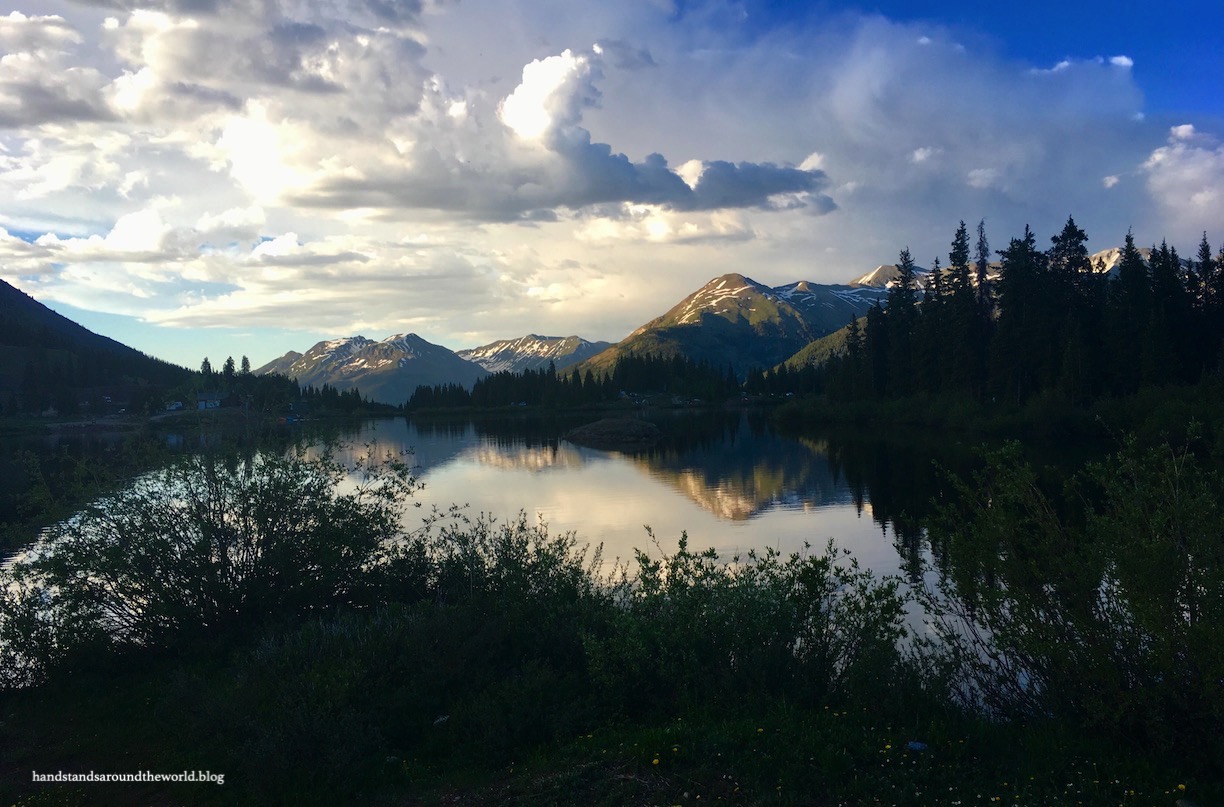
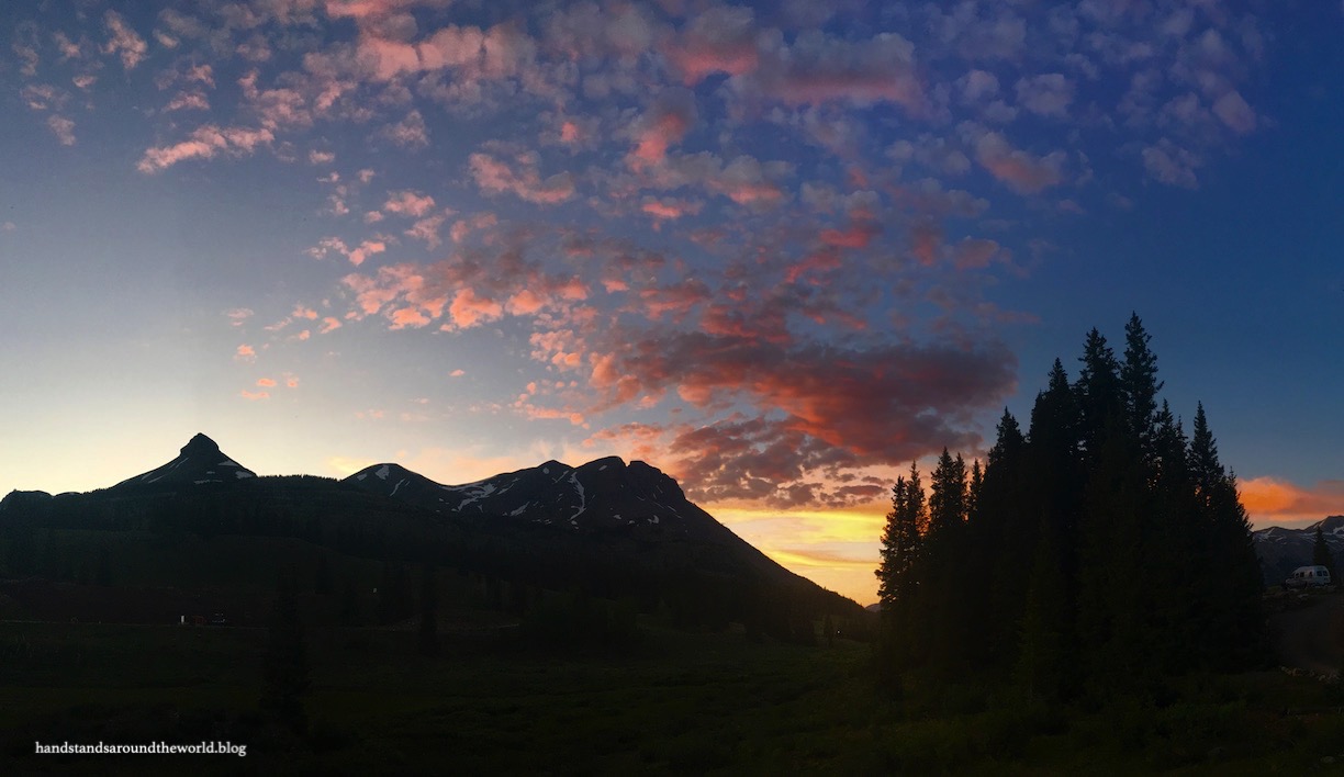
Our home base for our two days in the area was Molas Lake Park, which is quite possibly one of my favorite campgrounds of all time. There are a few lakefront sites, though they’re more expensive so we just reserved a regular tent site. And we may not have had lake views, but it was still one of the most scenic places we’ve ever pitched our tent!


I do have three complaints about this campground, one of which isn’t their fault and the other two of which wouldn’t deter me from staying here again.
(1) Mosquitoes. There was standing water behind our site, which I’m sure was the main reason for this issue. Later in the season or in drier years, I imagine the mosquito situation is less annoying.
(2) There aren’t enough bathrooms. There are only 3 or 4 pit toilets for the whole campground and, given that there was a line at least 50% of the time, I’d say they need to install at least one more.
(3) Showers. They’re $5 for 4 minutes. We opted to not partake, and just relied on flushable wipes as needed. However, there’s running water in the sinks in each shower stall that are free to use.
Well, there you have it. A detailed (and lengthy) description of the San Juan Skyway Scenic Byway. A Colorado bucket list item for sure!
Read more of my Colorado Bucket List series here.
The Important Stuff:
- Getting there: the Skyway forms a circle between Durango, Cortez, Placerville, and Ridgway, and can be accessed from highways leading into all four of these locations
- Fees and passes: none for driving the road, but parking and camping fees apply at certain locations along the Skyway
- Hiking: there are hundreds of hiking options all along the Skyway, check AllTrails or the Forest Service for trail information
- Where to stay: there are numerous Forest Service and private campgrounds all along the Skyway (Google Maps and the Forest Service website are good resources for this) and lodging options in every town along the way
- Other: due to the elevation and extreme nature of this road, it’s wise to check the weather before setting out; the road does close periodically due to winter storms, avalanches, and rockslides. Certain roads and campgrounds that branch off from the Skyway close in winter as well

That is definitely one the most scenic road in the US! I also wrote an article about the Million Dollar Highway on my blog 😀
LikeLiked by 1 person
Beautiful photos ..a long way from here so I can I only imagine travelling there and your posts certainly help 😎
LikeLiked by 2 people
Despite traveling to Colorado dozens and dozens of times over the years, this whole area remains unseen by us, and we clearly need to correct that! Keeping your post for future reference!
LikeLiked by 1 person
Sorry for the delayed reply. Thanks for reading, and I’m glad I could inspire you to visit this area. We actually went back this past summer and did some more hikes… posts on those upcoming. It’s my favorite part of the state and I hope you get to visit sometime soon!
LikeLiked by 1 person
We loved that part of Colorado! Thanks for taking us back 🙂
LikeLiked by 1 person
Beautiful scenery, for sure. Thanks for sharing.
LikeLiked by 1 person
See why I love my beautiful state of Colorado so much? I think I live in one of the most beautiful places in the world. 🙂
LikeLiked by 1 person
Agreed!
LikeLiked by 1 person
🙂 🙂 🙂
LikeLike
Favorite part of Colorado! 🧡
LikeLiked by 1 person
Wonderful post as always. I love Telluride, for sure one of my top 5 mountain towns.
LikeLiked by 1 person
We drove the whole circuit two years ago (counter-clockwise) starting and ending in Durango. So gorgeous. Loved Telluride – wish we could have spent more than an afternoon there.
LikeLiked by 1 person
Nice! I wish we’d had time to make it back to Durango and complete the whole loop. Loving Telluride seems to be a popular opinion, a lot of people have told me the same thing! We definitely can’t wait to visit again.
LikeLiked by 1 person
We love Telluride and Ouray! We started the drive on the million dollar Highway from Ouray, but didn’t go all the way to Silverton. With our big dually truck, my husband got way too nervous with those steep drop offs. The part we did see was very scenic though, so I hope to do it one day with a smaller vehicle. Great post!
LikeLiked by 1 person
Yeah, I can see how that would be nerve wracking… not exactly a lot of extra room for a wide vehicle. I couldn’t believe the number of semis and RVs we saw, I’d never want to navigate that road in something that large. Hope you guys make it back down there soon!
LikeLike
I can’t believe I’ve never been to Colorado! So much beauty. The Million Dollar Highway reminds me a bit of the Sea to Sky Highway that runs from just north of Vancouver to Whistler. It is gorgeously scenic and curvy and dangerous (sometimes nicknamed the Sea to Die). It used to be single lane, but the highway was upgraded for the 2010 Olympics so it’s a bit less treacherous. Thanks for the tour.
LikeLiked by 1 person
Well when you make it here someday I have lots of recommendations for you and I’m happy to give you guys a tour 🙂 You know, I lived in Washington for 4 years, about an hour from the border, and I never made it to Whistler. I wish I had. Definitely an area I’m going to need to return to, and now I’m excited to drive that highway!
LikeLiked by 1 person
I’ll take you up on that!
LikeLiked by 1 person
Excellent tour of my favorite area in Colorado. I can’t believe how much water is falling at Bridal Veil Falls. I always wanted to sign up for a guided ride/tour via Black Bear Pass but never got around to it, plus my husband wasn’t onboard with this treacherous excursion 😏
LikeLiked by 1 person
We would love to sign up for a jeep tour too! (Someday when we have a larger travel budget, they’re absurdly expensive.) The waterfall was nuts, there was so much snowmelt everywhere. I definitely understand now why this is your favorite part of the state, it’s mine too and we can’t wait to go back!
LikeLiked by 1 person
Fantastic photos! I miss mountais and being outdoors. Two more weeks of lockdown in Ireland, fingers crossed we’ll be able to go further than 2 km mark. Thanks for sharing and have a good day 😀 Aiva
LikeLiked by 1 person
Oh wow, you guys are really locked down. We’re “allowed” to go up to about 16km, although I don’t think police are strictly enforcing it. Unfortunately we’re more than 16km from the mountains though and I miss them too. Hope you guys are able to get back out there soon. Stay healthy!
LikeLike
Spectacular
LikeLiked by 1 person
Breathtaking landscape. What a joy to be surrounded by such glorious views. You are lucky! Mel
LikeLiked by 1 person
We feel fortunate for sure! Thanks for reading!
LikeLiked by 1 person
Love the picture of Molas Lake Park. The reflection on the water is beautiful! Great post!
Love Colorado!
LikeLike
Thank you! It was one of those photos that I just snapped without much thought but it turned out really well… I love when that happens! Thanks for reading 🙂
LikeLike