
Way back in 2007, my mom and I hiked to Hyalite Lake… a hike which I’ve previously written all about. It’s 11 miles (17.5 km) roundtrip, closer to 13 miles (21 km) when you add in all the detours to the many waterfalls along the way, and our feet were pretty exhausted by the time we were back to the car.
But the trail doesn’t end at Hyalite Lake. It continues an additional 2 miles (3.2 km) and 1500 vertical feet (460 m) up to Hyalite Peak, for a roundtrip total of 15 miles (24 km) and 3500 feet (1065 m) elevation gain. As we stood at Hyalite Lake all those years ago, we gazed up at the peak and promised ourselves we would come back and climb it one day.
It took 11 years – thanks to many factors – but in the summer of 2018 we finally checked this one off our list!
It wasn’t exactly the best day for a summit attempt; the air quality was subpar thanks to all the forest fires, and we ended up on top at the same time as a small rainstorm (which – annoyingly – proceeded to clear away as soon as we headed down). But I’d driven all the way up from Colorado and was only going to be home for a week and we had a bunch of other plans, too, so we really didn’t have the option to wait for another day.
My mom, her friend, and I were on the trail just after 8:00 am on a Wednesday in early August to begin our climb. The trailhead was relatively deserted, and we ended up being three of only a handful of people who summited that day. Three went up ahead of us, and we passed another five who were headed up as we were on the way down, but that was it. The lower section of the trail up to the waterfalls and lake sees more use, but most people don’t go all the way to the peak.
We made it to the lake in about 2.5 hours, the perfect place to stop for a snack before our final steep push to the summit. From Hyalite Lake, the trail winds moderately up through a large meadow which was absolutely overflowing with thousands upon thousands of wildflowers. There were monkey flowers and lupine, arnica and Indian paintbrush, mountain bluebells and aster and yarrow and columbine probably a few others. The combination of brilliant purples and yellows and pinks was incredible and added beauty to an already stunning section of the hike.


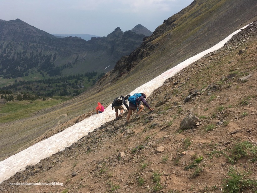
Beyond the meadow the trail begins to climb, switchbacking up the slope to the saddle just below Hyalite Peak. This is the steepest section of trail, and the last portion was made even more difficult by the fact that a field of snow stretched across the final switchback, forcing us to hike almost straight up to the ridge to avoid it. In addition to the few slippery steps up the snowfield, the entire slope was comprised of dirt and small rocks, making for some rather precarious footing; our situation was not helped by the wind that was picking up as the rain clouds rolled in. None of us owned microspikes at the time, but they would’ve been ideal (and much safer) for this upper section.

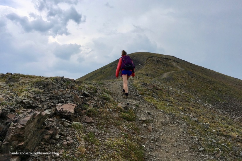
After a very steep climb, we caught up with the trail on the ridge and followed it the final distance to the summit at 10,299 feet (3139 m).
We managed to find a seat around the back side of the summit that was mostly out of the wind, allowing us a few minutes to have a snack and enjoy what there was of a view. Between the smoke and the rain, visibility was pretty poor… although we’ve had worse.


Thunder in the distance chased us off the summit after a few minutes, but the storm was (fortunately) headed in the other direction so the sun came out and the wind died down as we were descending. It was a bit hairy as we slipped and slid our way over the snowfield and down the hillside back to the trail, but from there it was a fairly easy – albeit long – descent back to the trailhead.
Just as the trail dropped back into the valley of flowers, we spotted some animals off in the distance that – after a prolonged debate – we identified as bighorn sheep. They were too far away for me to capture a good photo with my phone, but the shape and coloring just wasn’t quite right for deer. I’m 90% certain they were sheep, which is pretty neat because I’ve never seen those in Hyalite Canyon before.
We arrived back at the car around 5:00 pm exhausted, covered in dust, and with protesting legs and feet, but also with a feeling of accomplishment at finally checking this summit off our bucket lists!
The Important Stuff:
- Getting there: located at the end of Hyalite Canyon Road south of Bozeman, MT
- Fees and passes: none
- Hiking: 15 miles (24 km) with 3500 feet (1065 m) elevation gain to the summit of Hyalite Peak; difficult
- Where to stay: there are two campgrounds up Hyalite Canyon – Langohr and Chisholm. Be aware that Langohr Campground fills almost every night in the summer. If you stay in Bozeman, it will be about a 45-60 minute drive to the trailhead
- Other: this is a summit best attempted in late July or August due to the snowfield that covers the top section of trail for most of the year. If summiting any other time, bring appropriate gear to hike across the snow (i.e. microspikes, and probably a helmet and ice axe in the winter)

Hello! We are looking for getting usage rights for photos of Hyalite Peak. Would you be willing to let us use your photo in a new building at Montana State University? Please send me an email or phone call and I can give you more details. Thank you, Carley Smith
LikeLiked by 1 person
Unreal wildflowers! What a beautiful hike!
LikeLiked by 1 person
That’s quite the hike. I especially love the wildflowers. Aren’t microspikes the best invention! I bring them along all the time now. Thanks for providing distances and elevation in metric too.
LikeLiked by 1 person
They’re amazing! The first time I wore them I was blown away.
And no problem 😊 Gotta make this info readable for everyone!
LikeLike
Great images and the signature handstand.
LikeLike
Thank you!
LikeLiked by 1 person
Wow, you really hit it on the wildflower bloom!
LikeLiked by 1 person
We really did! I wasn’t expecting it to be so colorful
LikeLike