
I’ve been a lot of cool places. The US map on my bedroom wall is covered in pins; I’m up to 43 states and 57 National Park Service sites, not to mention 7 Canadian provinces and numerous national and provincial parks there as well.
So when I say that the Skyline Trail at Mount Rainier is quite possibly the most beautiful hike I’ve ever done, I have a decent number of locations to compare it to.
In fact, it’s one of the two Skyline Trails that can be found on my All-time Favorite Hikes list.
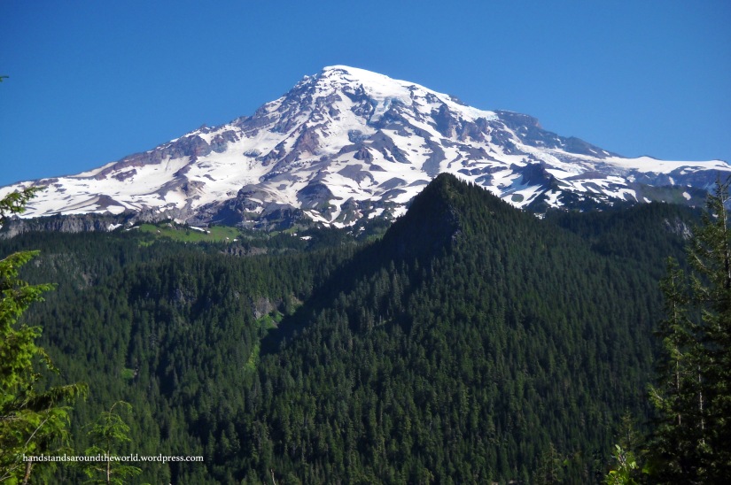
Of all our days in Mount Rainier National Park, this one was the warmest, sunniest, and by far the best. It began with a cloudless view of Mount Rainier from the main road as we drove from Cougar Rock Campground to the Paradise turnoff.
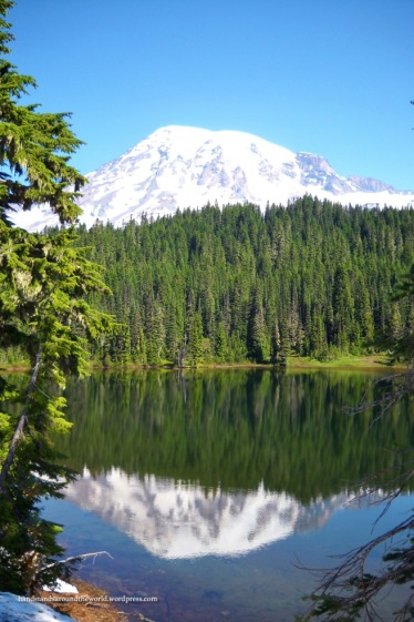
A last minute decision to backtrack to Reflection Lakes once more paid off. The wind was calm, the sky was clear, and the reflection of the mountain was stunning!
With our cameras now loaded with an excessive number of reflection pictures, we headed up to Paradise for our hike. The Skyline Trail is a 5.5 mile (8.9 km) loop that departs from the Jackson Memorial Visitor Center at Paradise.
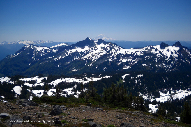
Beginning at the visitor center, we hiked in a clockwise direction. The trail ascends roughly 1,400 feet (430 m) to Panorama Point, the highest point on the trail; it provides spectacular views of Mount Rainier, the Tatoosh Mountain Range, and, on a clear day, Mount Adams way off in the distance.


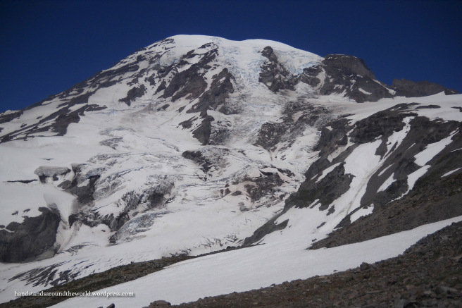

Around this area, we ran into a group of hikers who were on their way to the summit. It’s an 8 mile (12.9 km) hike to the summit from Paradise with a 9,000 foot (2740 m) elevation gain. Not for the faint of heart. You have to register and obtain the appropriate permits and they sell out months in advance, so watching the weather and picking a day to summit isn’t really an option.
Fortunately for the party we ran into, the weather was absolutely beautiful. The day before, anyone who summited would have been in and out of the clouds. Luck of the draw, I suppose, and these guys won the weather lottery!
Anyway, from Panorama Point, the trail begins to curve and descend. Supposedly there are hundreds of stairs to make the descent less treacherous, but I can’t say for sure since it was still covered in snow in most places. It was a bit of a slip-and-slide.
At one point, my sister walked up to what we assume was stairs, paused when she realized how far down the trail dropped, shrugged, squatted down, and simply sledded down the trail on her feet. From my vantage point, she just disappeared. It was hilarious, though maybe you had to be there to appreciate it.
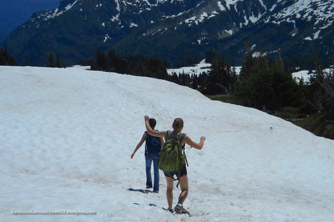
After slipping and sliding our way through the snow, we arrived at the junction with Golden Gate trail. This is the shorter way back to the visitor center; I recommend taking the long way. The long way is to follow the Skyline Trail as it continues to descend to Sluiskin Falls. The water for this falls originates from the glaciers of Mount Rainier and eventually flows into the Paradise River.
Shortly after the falls, we arrived at a junction. We went right, then right again at the next junction, following a trail through Paradise Meadows and past Myrtle Falls before arriving back at the visitor center.


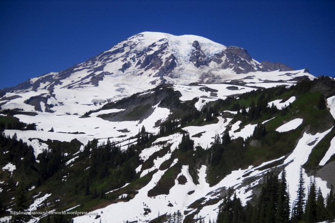
As with the rest of the park, the ground was covered in wildflowers of all colors, made even more brilliant by the sunshine. The snow sparkled and the views were panoramic, making the Skyline trail one of the most beautiful hikes I’ve ever done!


It’s probably obvious by now that you could spend 2 weeks at Mount Rainier and still not see everything the park has to offer. But if you only have a day or two, the Skyline Trail is, in my opinion, the absolute highlight!
The Important Stuff:
- Getting there: the Paradise section is located on Paradise Road, 25 mins northeast of Longmire, WA
- Fees & passes: $25 per car for a 7-day pass; Interagency Annual Pass accepted
- Camping: Cougar Rock Campground is located in the Paradise section of the park. 173 sites, $20 per night, reservations accepted but sites are also available first-come-first-serve
- Hiking: Skyline Trail; 5.5 mile (8.9 km) loop with 1400 feet (430 m) elevation gain
- Other: Snow, snow, and more snow. This was the end of July and the trail was still pretty well covered. Wear warm socks and waterproof shoes!

We absolutely loved this part of Rainier! It really is the most spectacular scenery for the work – you feel like you’re right up on the peak even though you’re only halfway up!
LikeLiked by 1 person
Right? I was a bit overwhelmed with how much we climbed and how comparatively far we still were from the summit. And also with how tiny we felt next to that giant mountain.
LikeLiked by 1 person
Your Panorama Point handstand is perfect! (more alliteration required)
LikeLiked by 1 person
Thanks 🙂
LikeLike
No wonder it’s at the top of your most beautiful hikes list!
LikeLiked by 1 person
Love it! Your handstand photo is the best one in front of the glacier!
LikeLiked by 1 person
Thanks! Really gives some perspective as to how enormous the mountain is…
LikeLiked by 1 person
The Skyline Trail remains one of my all-time favorite hikes too. 🙂 Your photos were gorgeous as always!
LikeLiked by 1 person
Thank you 🙂
LikeLike
I added this gem to my notes for when we visit in 2 years. Thanks!
LikeLiked by 1 person
Oh yay, glad I could help!
LikeLike
So incredibly beautiful!! Sad to say that we lived in Seattle for quite some time but never to Paradise as we can’t drive 😦 We’ll come back soon.
LikeLiked by 1 person
What a gorgeous place ♥
LikeLiked by 1 person
Stunning blue sky sunny day photos. Louise
LikeLiked by 1 person
Stunning – absolutely beautiful. Thanks for my mountain wildflower fix. I’m sure missing them this year!
LikeLiked by 1 person
Thank you!
LikeLike
This looks a pretty place to spend the day. The reflection shot is nice, so I can see how you could easily fill up a camera with it.
LikeLiked by 1 person
Thanks! It really is a stunning place.
LikeLike